A report on the project is expected to be submitted to the Infrastructure and Environment Committee (IEC) in February 2026, followed by City Council in March 2026. Meeting agendas are posted one week in advance of the IEC meeting and include opportunity to register to speak or send a written submission.
A Virtual Public Meeting was held on March 9, 2023.
View the presentation below (PDF):
The City has hosted two public drop-in events to engage residents and stakeholders on this study. Both events had the same information materials and opportunities to discuss this study with the project team.
West Location (Emery Village BIA)
Date: November 28th, 2019,
Time: drop in between 3 and 8 p.m.
Location: Julius Event Centre
2201 Finch Ave. W., North York M9M 2Y9
East Location (DUKE Heights BIA)
Date: December 2nd, 2019
Time: drop in between 3 and 8 p.m.
Location: Downsview Park Hub
70 Canuck Ave., Toronto M3K 2C5
Learn more about the study by reviewing the following:
A Stakeholder Workshop was held with local businesses on April 11, 2019.
View the presentation materials below (PDFs):
Read the results of the workshop:
For more information, or to be added to our mailing list, please contact the person listed on this page.
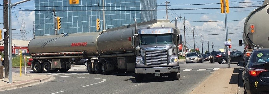
Line 6 Finch West opened to TTC customers on December 7, 2025. While the LRT will benefit the community in many ways, it will also introduce new turning restrictions and other changes to local roads and freeways. These changes will affect how businesses ship their goods and make freight deliveries.
The City is conducting the Finch West Goods Movement Transportation Master Plan to identify strategies that address the future shipping and freight delivery needs in the study area while considering the safety and efficiency of travel for commuters, transit users, cyclists and pedestrians. This Transportation Master Plan (TMP) will be completed to evaluate and select infrastructure improvements and outline an implementation strategy. The TMP will document phases 1 and 2 of the Schedule C Municipal Class Environmental Assessment process, which includes the opportunity for public input.
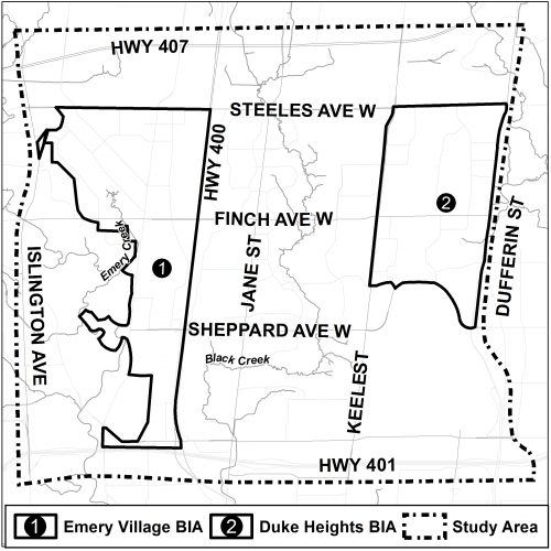
The study area is bounded by Dufferin Street and Islington Avenue (east-west), and Highways 407 and 401 (north-south). This includes the Emery Village and Duke Heights Business Improvement Areas (BIAs).
In late 2014, a Truck Technical Working Group was established as part of the Finch West LRT stakeholder engagement consisting of the Emery Village (BIA), the Canadian Fuels Association (CFA) and others. This group met on four occasions and arrived at a consensus to conduct an area-wide transportation study to examine freight-related solutions.
Additionally, a number of other initiatives have also identified potential improvements in the area. This includes the Downsview Area Transportation Master Plan (2016), the Downsview Area Secondary Plan (2010), the Emery Village Transportation Master Plan (2009), and the Emery Village Secondary Plan (2001), among others.
This Goods Movement TMP is being prepared in accordance with the Municipal Class Environmental Assessment (EA) process. The study will identify and prioritize short-term (“quick win” 0-3 years), medium-term (5+ years), and long-term (10+ years) improvements to the transportation network.
This study aims to improve existing infrastructure to facilitate easier movement throughout the study area, as well as increase access to 400 series highways. This will help alleviate the existing issues, as well as prepare for future changes in the area, including the Finch West LRT.
Some of the smaller recommendations could result in increased “green time” at traffic lights, allowing for more vehicles to pass through an intersection, or reducing parking availability where parking creates a conflict with the ability of a truck to access roads or buildings.
Vehicles that move goods around the city are often travelling in proximity to vulnerable road users including cyclists and pedestrians. The recommendations that result from this study may include new dedicated facilities for pedestrians and cyclists (as part of a new road/bridge) or could resolve an existing problem where a road redesign is recommended. The City’s focus on Vision Zero ensures that the study recommendations will include safer designs for those vulnerable road users.
A key aim of this study is to minimize the conflicts between truck routes and other land uses (homes, schools, etc.). As such, this study is looking at improving trucking routes further away from sensitive land uses, making them more convenient than those near sensitive land uses. When these improvements are in place, it is expected to result in a decline in trucks travelling through residential areas.
Although Finch Avenue West is within the study area, the designs for the Finch West Light Rail Transit are at an advanced stage, and the opportunity for design suggestions or changes has passed. The approach to this study has been to create and improve connections within the study area to reduce the reliance on Finch Avenue West for moving goods to and from the study area.
Trucking behaviour is not within the scope of this study, but the recommendations should help to reduce conflicts between truck drivers and other road users, and between truck traffic and sensitive land uses.