In November 2023, North York Community Council (NYCC) approved the installation of the Leaside Neighbourhood Transportation Plan’s Near-Term Plan, with amendments (2023.NY9.6). Later in 2025, City staff expect to report to NYCC about installing an Intersection Pedestrian Signal at the Bayview Avenue/Sutherland Drive intersection (2023.NY9.5).
The City of Toronto is developing the Leaside Neighbourhood Transportation Plan (LNTP) to address the concerns about transportation conditions in the neighbourhood raised by the community, as well as any related items identified by staff through the course of the study.
The plan will identify, recommend and prioritize changes that can be made to improve safety for all road users, with a focus on vulnerable road users such as pedestrians, people biking, children and seniors.
The plan consists of two phases: a near-term plan and a long-term plan.
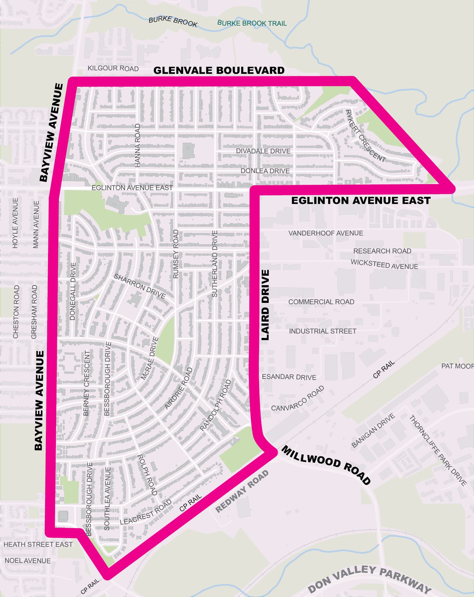
Study Area
The study area is bound by Glenvale Boulevard/Kildeer Crescent/Rykert Crescent (north); rail corridor (south); Don River and Laird Drive (east) and Bayview Avenue (west).
Process
Near-Term Plan (Phase 1: 2022–2026)
Spring/Summer 2022: Gather site-specific concerns and ideas
Fall 2022/Winter 2023: Data analysis and site visits and observations
Spring 2023: Gather public feedback on proposed near-term changes
Late 2023+: Implement near-term changes
Long-Term Plan (Phase 2: After Completion of Line 5 Eglinton & Bikeway)
Study new travel patterns and public consultation
Near-Term Plan (Phase 1: 2022–2025)
Data Collection & Analysis
The City reviewed traffic studies and travel data to identify, recommend and prioritize changes to traffic operations and road design that can be made in the coming years:
Measurements of vehicle volumes, speeds and turning movement counts
Collision data collected by Toronto Police Services
Recent reports about traffic operations and road safety
Site visits and observations
Past and ongoing plans and studies
Resident input through public consultation
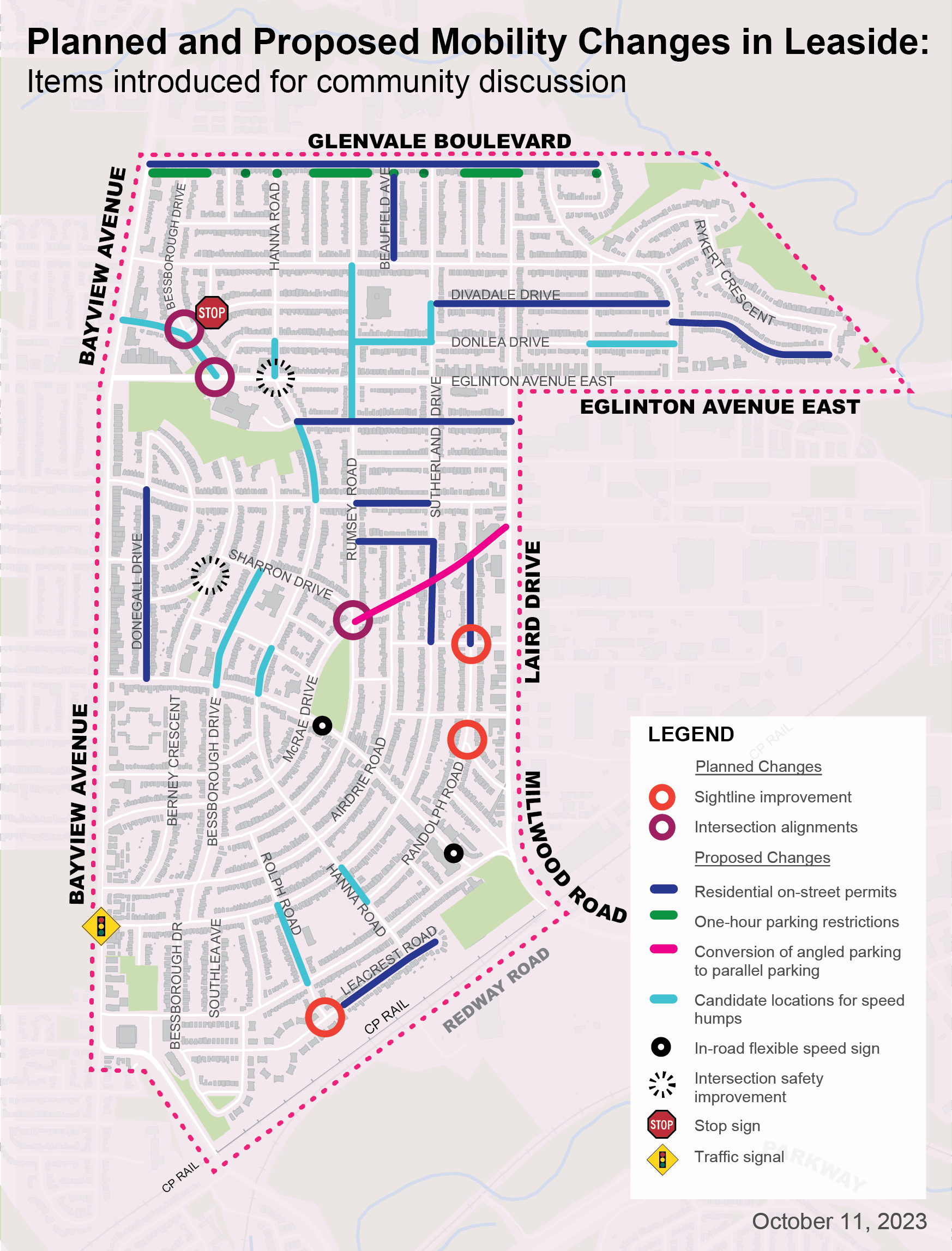
The City has identified possibilities to improve safety for all road users, especially vulnerable road users such as pedestrians, people who bike, children and seniors.
The following changes do not require Council approval or have already been approved by City Council:
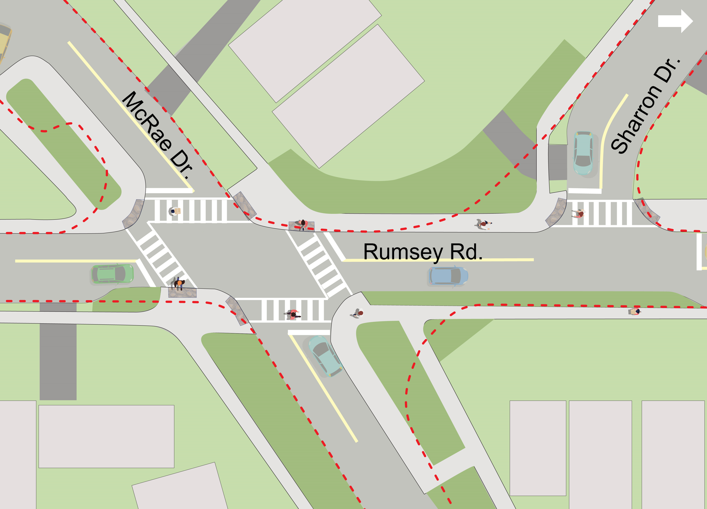
Vision Zero intersection realignment and safety improvements at McRae Drive/Rumsey Road/Sharron Drive
Sightline improvements at intersections to remove obstructions at Randolph Road/Kenrae Road, Randolph Road/Stickney Avenue and Rolph Road/Southvale Avenue
In-road flexible speed signs on portions of Millwood Road
State-of-good-repair review of pavement markings
Line 5 Eglinton
Bikeways on Eglinton Avenue East and Millwood Road
Completed
The following planned changes have been implemented:
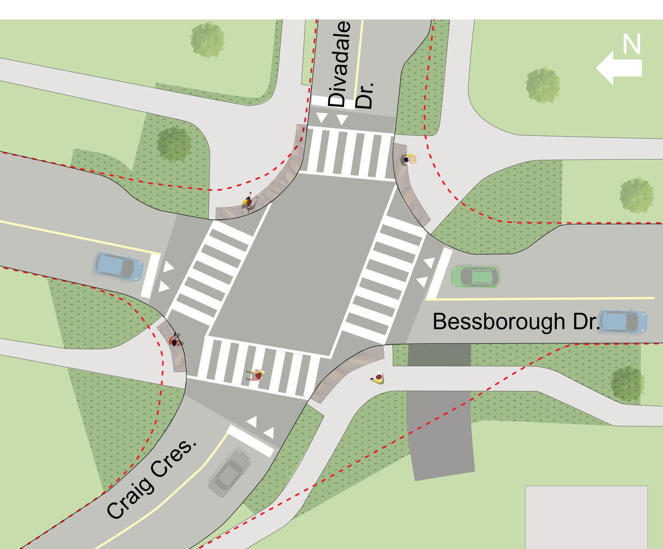
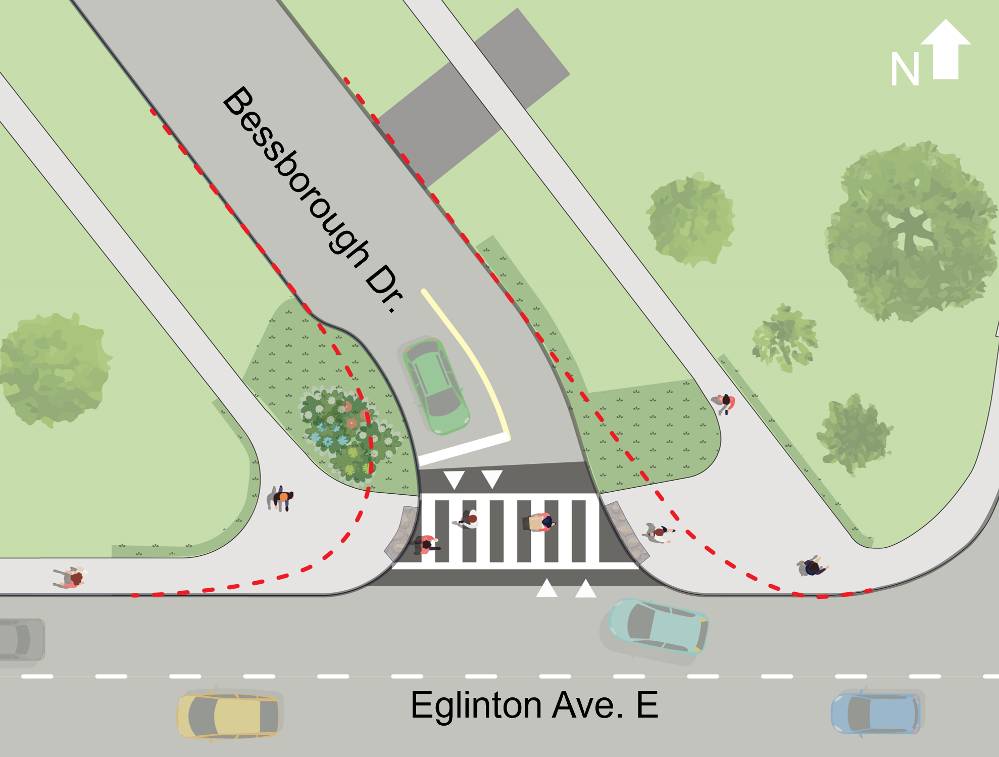
Vision Zero intersection realignment and safety improvements at Bessborough Drive/Craig Crescent/Divadale Drive and Bessborough Drive/Eglinton Avenue East
Installation of a Bike Share Toronto station at the Toronto Public Library (Leaside Branch) and McRae Drive/Laird Drive
Approved Changes
The following changes have been approved by NYCC:
Speed humps on portions of roadways in school and community safety zones (contingent on resident polling). Further outreach will be undertaken before the City Clerk’s Office issues polls to impacted residents.
By-law changes to allow on-street, overnight parking permits (contingent on resident polling)
Completed
The following approved changes have been implemented:
Speed limit reduction from 40 km/h to 30 km/h on Moore Street, from Bayview Avenue to Southvale Drive
Replacement of yield sign with a stop sign at Winsloe Avenue, approaching Divadale Drive
One-hour parking restriction on Glenvale Boulevard, from Hanna Road to Brentcliffe Road
Proposed Changes Requiring Further Studies
City staff will report to NYCC in late 2024 with a review of the feasibility of installing an intersection pedestrian signal at Bayview Avenue/Sutherland Drive:
NYCC has directed City staff not to proceed with the following proposed changes:
Conversion of angled parking to parallel parking on portions of McRae Drive
Planned & proposed near-term mobility changes in Leaside
Long-Term Plan (Phase 2: After Completion of Line 5 Eglinton & Bikeway)
Travel behaviour changes associated with the new transit and transportation infrastructure must be studied before major network changes are considered.
The development of the long-term plan will begin after the completion of Line 5 Eglinton and the planned bikeway on Eglinton Avenue, from Bayview Avenue to the Don Valley.
The long-term plan may consider road redesign elements like:
traffic diversions
separated bikeways
road narrowing
other interventions that are typically delivered as part of road reconstruction
Public Consultation
The comment period for Phase 1 consultation has closed. The Public Consultation Report summarizes feedback received.
Virtual Public Meeting
A virtual public meeting was held on June 7, 2023, that included a presentation and Question & Answer period to speak with project staff.
From July 18 to September 3, 2022, members of the public were able to locate areas of interest and concern using a digital mapping tool. A total of 257 unique respondents submitted 458 comments.
A public information session was held on February 9, 2022. The information session included a presentation on the LNTP objectives, challenges and opportunities, toolbox of strategies and study process. It was followed by an opportunity to ask questions and provide feedback on locations that would benefit from safety improvements for all road users.
In addition to the LNTP, the City is also making changes to the design of three intersections within the study area in support of the Council-approved Vision Zero Road Safety Plan.
The City plans permanent road safety improvements at intersections where:
state-of-good-repair reconstruction or resurfacing is planned
temporary safety treatments have been installed to address specific safety concerns
The planned changes will address safety concerns by reducing crossing distances and slowing vehicle speeds. The work will involve removing and reconstructing curbs and sections of sidewalk, as well as replacing asphalt. Designs will bring intersections up to current standards and guidelines.
All intersection construction is anticipated for completion in spring 2024, pending contractor availability. Information on what to expect during construction will be mailed to residents in advance.
Added tactile plates at corners to meet accessibility standards
Protected all existing trees
Aerial view of the completed Vision Zero improvements at Bessborough Drive/Craig Crescent/Divadale Drive
Reconstructed: Bessborough Drive/Eglinton Avenue East
Realigned intersection to a more normalized “T” with curb extensions at both corners. This will help slow vehicles, improve sightlines and decrease pedestrian crossing distances.
Raised crossing and added high-visibility zebra markings to improve stop compliance and yielding to people crossing
Extended sod boulevards and sidewalks to provide safer waiting areas for people crossing
Tightened corner radii to reduce vehicle turning speeds
Added tactile plates at corners to meet accessibility standards
Protected all existing trees
Aerial view of the completed Vision Zero improvements at Bessborough Drive/Eglinton Avenue East
Remove right-turn channel islands and normalize intersections with curb extensions at most corners. This will help slow vehicles, improve sightlines and decrease pedestrian crossing distances and conflict points with motor vehicles.
Add high-visibility zebra markings at all crossings to improve stop compliance and yielding to people crossing
Extend sod boulevards and sidewalks to provide safer waiting areas for people crossing
Tighten corner radii to reduce vehicle turning speeds
Add tactile plates at corners to meet accessibility standards
Protect all existing trees
Relocate existing southbound bus stop
Aerial view of the completed Vision Zero improvements at McRae Drive/Rumsey Road/Sharron Drive
Background
About the Neighbourhood Transportation Plan
In 2019, North York Community Council (2019.NY9.12), directed City staff to work with the community to develop a comprehensive plan to address community concerns about mobility in Leaside:
Cut-through traffic patterns
Speeding by motor vehicles
Volume of motor vehicles on local roads
Non-compliance with traffic regulations
Road user safety
Atypical geometric design of intersections and road curves
City staff have used a holistic approach to assess and manage traffic issues within the neighbourhood. The LNTP considers all modes of transportation, with an emphasis on improving conditions for vulnerable road users.
In 2023, the City launched Neighbourhood Streets Plans, to make it fair and transparent for neighbourhoods to access City-led community-guided plans for traffic, road safety and active transportation. The LNTP is considered an early entrant and model for this new program.
Recent Improvements
Alongside the LNTP initiative, safety measures have recently been implemented in the Leaside area to improve conditions for road users, with a focus on those that are vulnerable:
Speed limit reductions were implemented on all arterial, collector and local roads in the area.
Four School Safety Zones and six Community Safety Zones have been designated to help reduce aggressive driving and speeding in areas where vulnerable road users are likely to be present.
Pedestrian head start signals, also known as leading pedestrian intervals, have been added to five signalized intersections in the area.
A curb radius reduction was implemented at the intersection of Bessborough Drive, Craig Crescent and Divadale Drive to increase visibility between all road users, reduce the crossing distance for pedestrians and reduce vehicle turning speeds.
Challenges & Opportunities
The study area has been impacted by changes associated with transit projects, development applications and planning studies:
Neighbourhood road reconstruction and opportunities to bundle enhanced transportation improvements
Council Decisions
October 17, 2023: Leaside Neighbourhood Transportation Plan (Near-Term Plan) (2023.NY9.6) and Bayview Avenue and Sutherland Drive – Traffic Control Signals (2023.NY9.5)
November 29, 2022: Leaside Neighbourhood Transportation Plan Status Update (2023.NY1.9)
June 28, 2022: Request for a Status Report on the Leaside Neighbourhood Transportation Plan (2022.NY33.61)
October 10, 2019: Leaside Traffic Management Plan and Speed Limit Reduction (2019.NY9.12)
August 12, 2014: Report Request – Proposed 30 km/h Road Speed Limit Throughout Leaside (2014.NY34.103)
While we aim to provide fully accessible content, there is no text alternative available for some content on this site. If you require alternate formats or need assistance understanding our maps, drawings or any other content, please contact nsp@toronto.ca or 311.