April Update: City Council has approved the installation of road safety and streetscape improvements on Bathurst Street between Steeles Avenue and Bainbridge Avenue and Raoul Wallenberg Road. A copy of the staff report is available at IE19.1.
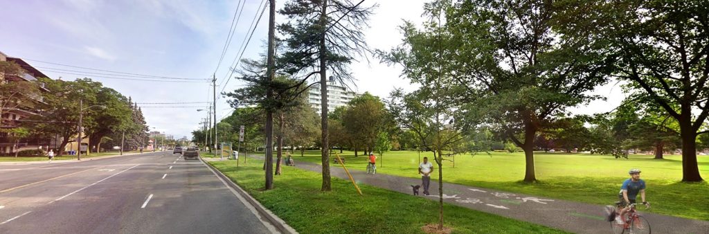
The City of Toronto has approved the installation of road safety and streetscape improvements along 4.7 kilometers of Bathurst Street from Steeles Avenue to Bainbridge Avenue and Raoul Wallenberg Road. The project includes road resurfacing along with approved changes such as new off-street multi-use trails, cycle tracks in the boulevard next to the sidewalk, bus stops enhancements and relocations, tree planting, and greening to capture storm water. The approved changes are part of the Council approved 2025 – 2027 Cycling Network Plan, and incorporate complete street features to fulfill the City’s commitment to the Vision Zero Road Safety Plan. No motor vehicle travel lanes are planned to be removed.
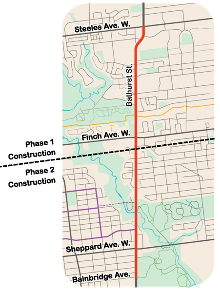
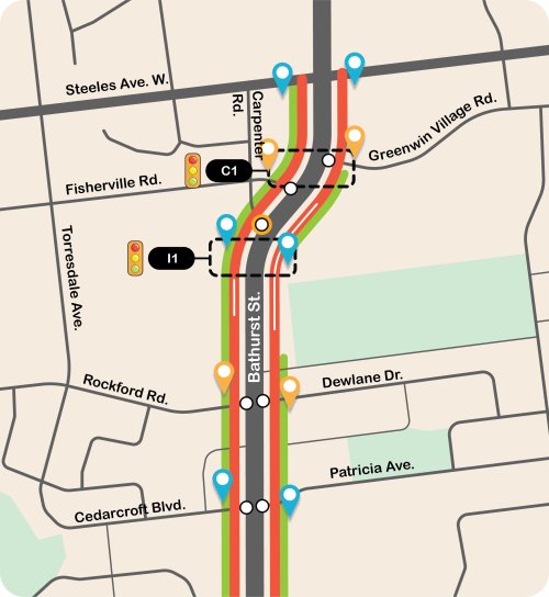
Project Area
The cycle tracks and multi-use trails would be in the boulevard and not on the roadway. They would connect to several trails and bikeways in and around the Bathurst Manor area and link to the public transit routes on Steeles Avenue West, Finch Avenue West and Sheppard Avenue West. There are no proposed changes to motor vehicle travel lanes.
The project is planned to be constructed in two phases:
Phase One, between Steeles Avenue and Kingsbridge Court, would be constructed in 2026 and 2027.
Phase Two, between Finch Avenue and Bainbridge Avenue, would be constructed in 2028 and 2029.
Overview of Approved Changes
Approved changes include:
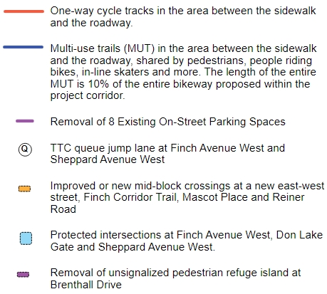
One-way cycle tracks next to the sidewalk installed between:
Steeles Avenue West and the entrance to the Sherman Campus (Prosserman Jewish Community Centre), and;
Canyon Avenue and Sheppard Avenue West
Multi-use trails separate from the roadway, shared by pedestrians, people riding bikes, and others, installed between:
The entrance to the Sherman Campus (Prosserman Jewish Community Centre) and Canyon Avenue and;
Sheppard Avenue West to Raoul Wallenberg Road
Tree and shrub planting areas in the areas between the cycle track and the sidewalk
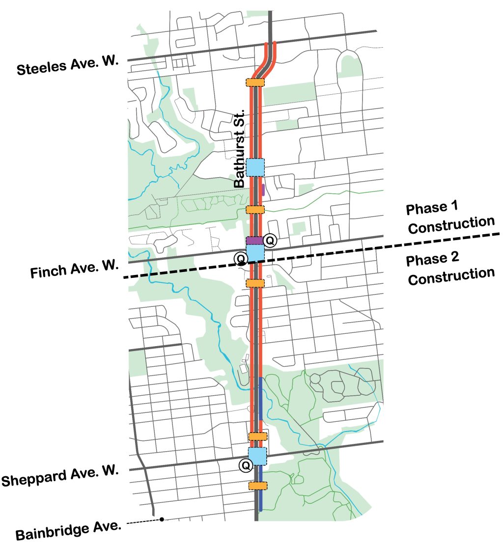
TTC queue jump lanes at Finch Avenue West and Sheppard Avenue West
Improved mid-block crossings at the Finch Hydro Corridor Trail, Mascot Place and Stafford Drive
New mid-block crossing at Reiner Road
Intersections safety improvements at Finch Avenue West, Don Lake Gate and Sheppard Avenue West
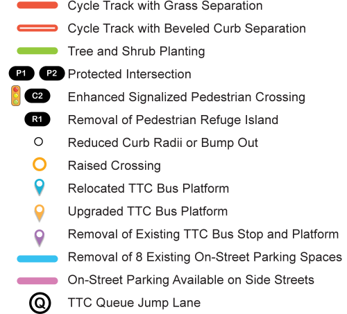
Removal of unsignalized pedestrian refuge island at Brenthall Avenue
Removal of 8 on-street parking spaces between Kenton Drive and Transwell Avenue. On-street parking is available on Kenton Drive and Transwell Avenue
One-Way Cycle Track Design Proposals
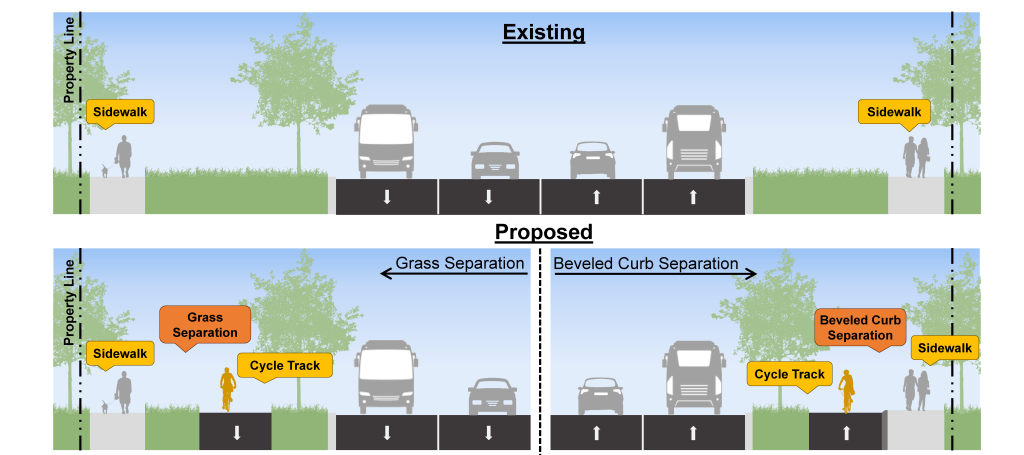
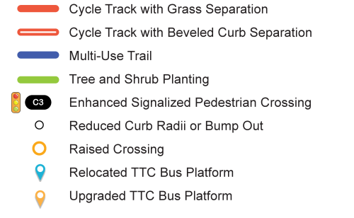
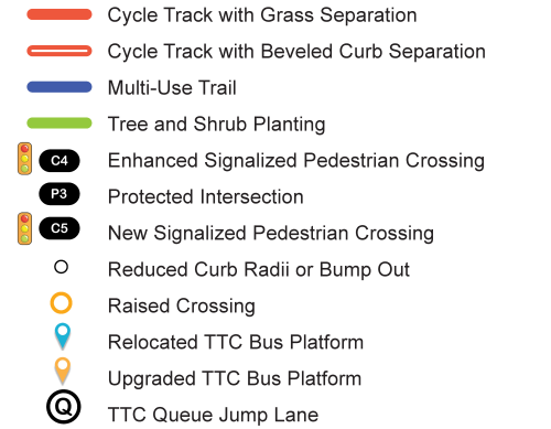
The design includes one-way cycle tracks in the area between the sidewalk and the roadway. The approved cycle track is separated from the sidewalk with either a grass or beveled curb separation.
Grass separation areas are either sodded or shrub-planted areas and are planned where the area between the roadway and property line is wide enough to accommodate a cycle track and a minimum 1.0m softscape separation.
A beveled curb is a 45cm-wide concrete curb. Beveled curbs are planned where the area between the roadway and property line is not wide enough to accommodate both cycle track and a 1.0m-wide grass separation.
Multi-Use Trail Design Proposal
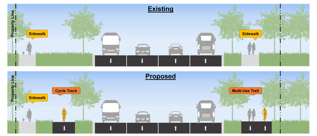
Multi-use trails are planned where the area between the roadway and property line is too narrow for a separated sidewalk and cycle track. Multi-use trails will be shared by pedestrians, people cycling, in-line skaters and more.
Approved Changes: Steeles Avenue West to Mid-Block between Patricia Avenue and Drewry Avenue.
This segment is within the Phase 1 construction project limit and includes the following changes:
East side of Bathurst Street:
Reduced curb radii at Greenwin Village Road, Dewlane Drive and Patricia Avenue
Relocated TTC Bus Platforms at Steeles Avenue West, a new east-west street to be realized as part of future residential development and Patricia Avenue
Upgraded TTC Bus Platforms at Greenwin Village Road and Dewland Drive
West side of Bathurst Street:
Reduced curb radii at Fisherville Road, a new east-west street to be realized as part of future development, Rockford Road and Cedarcroft Boulevard
Relocated TTC Bus Platforms at a new street east-west street to be realized as part of future residential development and Cedarcroft Boulevard
Upgraded TTC Bus Platforms at Steeles Avenue West, Fisherville Road and Rockford Road
One-way cycle tracks on both sides of Bathurst Street
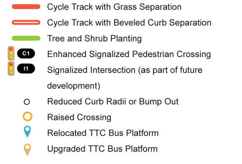
Signalized intersection at Bathurst Street and a new east-west street to be realized as part of future residential development
New trees and shrubs on both sides of Bathurst Street
No changes to motor vehicle travel lanes, including turning lanes. Parking is not permitted on this segment of Bathurst Street
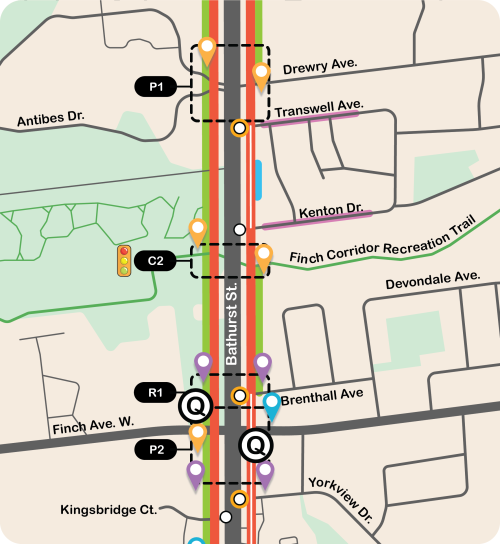
Approved Changes: Mid-Block between Patricia Avenue and Drewry Avenue to Yorkview Drive
This segment is within the Phase 1 construction project limit and includes the following changes:
East side of Bathurst Street:
Reduced curb radii at Transwell Avenue, Kenton Drive and Yorkview Drive
Relocated TTC Bus Platforms at Brenthall Drive
Upgraded TTC Bus Platforms at Drewry Avenue and the Finch Corridor Recreational Trail
Removal of un-signalized pedestrian island at Brenthall Avenue
West side of Bathurst Street:
Reduced curb radii at Kingsbridge Court
Upgraded TTC Bus Platforms at Patricia Avenue, the Finch Corridor Recreational Trail and Finch Avenue West
Protected intersections at Bathurst Avenue and Patricia Avenue and Bathurst Street and Finch Avenue West
One-way cycle tracks on both sides of Bathurst Street that connect to the Finch Corridor Recreational Trail
Upgraded Signalized Pedestrian Crossing at Bathurst Street and Finch Hydro Corridor Trail
TTC Queue jump lanes on both sides of Bathurst Street at Finch Avenue West
New trees and shrubs on both sides of Bathurst Street
Removal of 8 on-street parking spaces between Kenton Drive and Transwell Avenue. On-street parking is available on Kenton Drive and Transwell Avenue
No changes to motor vehicle travel lanes, including turning lanes
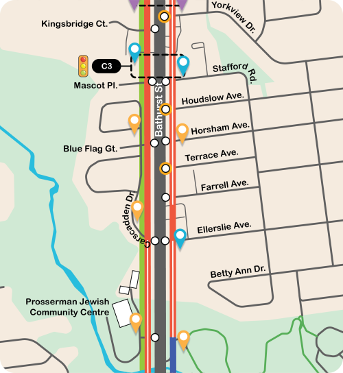
Approved Changes: Yorkview Drive to Sherman Campus (Prosserman Jewish Community Centre) Entrance
This segment is within the Phase 2 construction project limit and includes the following changes:
East side of Bathurst Street:
Reduced curb radii at Horsham Avenue
Relocated TTC Bus Platform at Stafford Road and Ellerslie Avenue
Upgraded TTC Bus Platforms at Horsham Avenue
West side of Bathurst Street:
Reduced curb radii at Kingsbridge Court, Blue Flag Gate, Carscadden Drive and the Sherman Campus (Prosserman Jewish Community Centre) Entrance
Upgraded TTC Bus Platforms at Blue Flag Gate, Carscadden Drive and the Prosserman Jewish Community Centre Entrance
One-way cycle tracks on both sides of Bathurst Street
Upgraded Signalized Pedestrian Crossing
New trees and shrubs on both sides of Bathurst Street
No changes to motor vehicle travel lanes, including turning lanes. Parking is not permitted on this segment of Bathurst Street
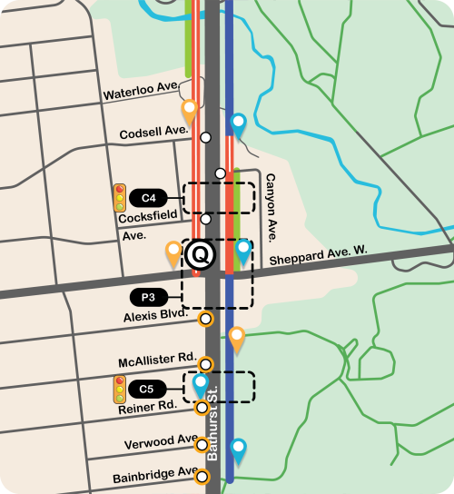
Approved Changes: Sherman Campus (Prosserman Jewish Community Centre) Entrance to Bainbridge Avenue and Raoul Wallenberg Road
This segment is within the Phase 2 construction project limit and includes the following changes:
East side of Bathurst Street:
Reduced curb radii at Canyon Avenue
Relocated TTC Bus Platform at the private driveway access across from Codsell Avenue and Sheppard Avenue West
Upgraded TTC Bus Platform at Raoul Wallenberg Road
Multi-use Trail between Raoul Wallenberg Road and Sheppard Avenue West and north of Canyon Avenue to Codsell Avenue Crossing.
One-way cycle track between Sheppard Avenue West and the private driveway access across from Codsell Avenue
West side of Bathurst Street:
Reduced curb radii at Codsell Avenue and Cocksfield Avenue
Upgraded TTC Bus Platforms at Codsell Avenue and Sheppard Avenue West
Relocated TTC Bus Platform at Reiner Road
One-way cycle track
Signalized Pedestrian Crossings at Cockfield Road and Reiner Road
TTC Queue jump lanes on both sides of Bathurst Street at Sheppard Avenue West
Protected Intersection at Bathurst Street and Sheppard Avenue West
New trees and shrubs on both sides of Bathurst Street
No changes to motor vehicle travel lanes, including turning lanes. Parking is not permitted on this segment of Bathurst Street
Public Consultation
Public consultation provided the public with an opportunity to learn more about the project and to give input on the proposed designs.
Bathurst Street and Finch Avenue West Accessibility Site Visit
On November 27, 2024 the Cycling and Pedestrian Projects Unit led an accessibility site visit of accessibility advocates and people with disabilities to incorporate accessibility needs in the project design. View the Report.
Public Consultation Event
A Public Consultation Event was held on Thursday, January 30, 2025 at Rockford Public School.
While we aim to provide fully accessible content, there is no text alternative available for some of the content on this page. If you require alternate formats or need assistance understanding our maps, drawings or any other content, please contact us at 416-338-2986 or email bathurstcompletestreet@toronto.ca.
Background
Bathurst Street is programmed for major roadway resurfacing between 2025 and 2028 which provides opportunities to implement a Complete Street design approach. Complete Streets are streets that are designed to be safe for all users: people who walk, bicycle, take transit or drive, and people of varying ages and levels of ability.
107 pedestrian were struck by vehicles along the corridor between 2012 and 2022, including 14 reported incidents resulting in a killed or seriously injured pedestrian.
36 collisions involved people cycling between 2012 and 2022.
The current posted speed limit is 50 kilometers/hour, however drivers typically travel between 66 and 73 kilometers/hour.