While City Council endorsed the long-term Eglinton Connects plan in 2014 and approved the eglintonTOday Complete Street project in 2024 to address gaps in the bikeway network along the 19 km Eglinton Crosstown LRT, the City is unable to complete the project at this time due to changes to the Provincial Highway Traffic Act.
In 2014 City Council approved the Eglinton Connects Planning Study which established a long-term vision for Eglinton Avenue following the introduction of the Eglinton Crosstown LRT. The study envisioned a complete street guided by three integrated themes of Travelling Eglinton, Greening Eglinton and Building Eglinton.
The eglintonTOday Complete Street project was developed as an interim strategy to achieve elements of the Eglinton Connects vision and make travel along Eglinton Avenue safer, more inviting and more attractive for everyone.
Complete street features were to include bikeways and public realm upgrades on Eglinton Avenue between Bicknell Avenue (west of Keele Street) and Mount Pleasant Road. These improvements would have reallocated existing road space to support a range of uses, including vehicle travel, parking, cycling, seasonal patios, public art installations, and neighbourhood and cultural events.
News & Updates
Eglinton Allen Intersection Study
Visit the NEW Eglinton Allen Intersection Study for details about the intersection redesign of the Eglinton Avenue West and the Allen Road Expressway and addressing traffic congestion on neighbourhood streets.
Project Area
Eglinton Avenue is a diverse and varied corridor. The first phase of the eglintonTOday Complete Street project extended along Eglinton Avenuebetween Bicknell Avenue in the west and Mount Pleasant Road in the east. Eglinton Avenue connects numerous unique neighbourhoods including Little Jamaica in the vibrant Eglinton West enclave between Allen Road and Keele Street, is home to more than six Business Improvement Areas and has strategic connections with the natural valley systems, ravines and trails of the larger city and region.
Installation between Avenue Road and Chaplin Crescent (within the limits of the Eglinton Way BIA) was completed in the fall 2024.
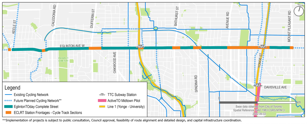
The project area is Eglinton Avenue between Bicknell Avenue and Mount Pleasant Road.
Approved Changes
Overview
The City planned for road safety improvements, new bikeways, and enhanced streetscaping. Traffic lane changes varied throughout the corridor depending on existing roadway width and traffic volumes, but typical sections were to include the following:
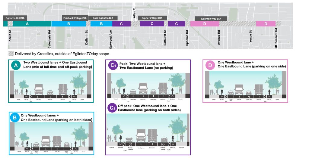
At least one travel lane per direction; some sections can accommodate two travel lanes in one direction or two lanes during peak hour travel
On-street parking or loading would be provided on one or both sides of the street, or during off-peak periods only. Potential parking impacts could include the relocation of some on-street parking and the conversion of peak-hour-only parking to all-day parking to support local businesses where traffic volumes permit
Space for CaféTO applicants (seasonally)
Turn lanes at intersections where appropriate and feasible
Addition of protected cycle tracks with various buffer treatments from Keele Street to Mount Pleasant Road.
Streetscape features include parkettes, seating, planters and public art etc.
Design Updates
Based on input from BIAs, residents and the eglintonTOday Stakeholder Advisory Group, some adjustments were made to the original proposal to better accommodate parking and loading, accessibility, congestion and neighbourhood infiltration on a block-by block basis. These minor changes did not change the general cross sections shared above.
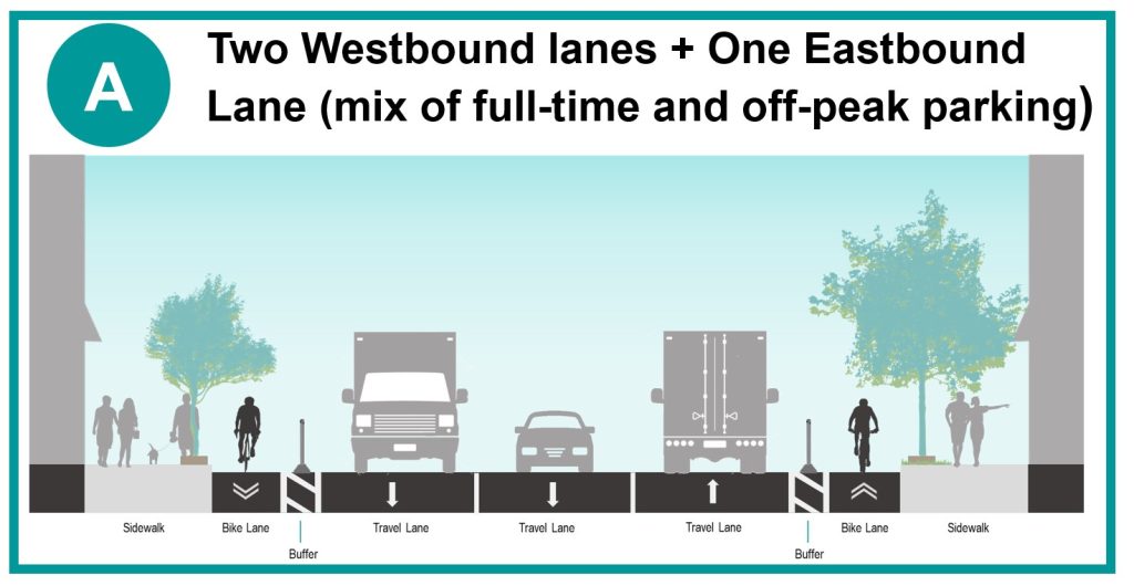
Bicknell Avenue to Caledonia Road
Cross-section for Bicknell Avenue to Caledonia Road.
The changes for the section between Bicknell Avenue to Caledonia Road included:
One-way cycle tracks with various buffer treatments. New north-south contra-flow bike lanes on Croham Road.
Two westbound motor vehicle lanes and one eastbound motor vehicle lane. Lane configuration at intersections varies.
Consideration for a new traffic signal at Eglinton Avenue and Croham Road. Signal upgrades and signal timing changes at various locations, including bike signal heads and leading pedestrian interval.
Proposed 24/7 on-street parking on the south side of Eglinton Avenue between Bicknell Avenue and Yarrow Road.
Keele Street intersection and streetscape improvements, including raised cycle tracks constructed by Metrolinx/Crosslinx as part of the Eglinton Crosstown LRT.
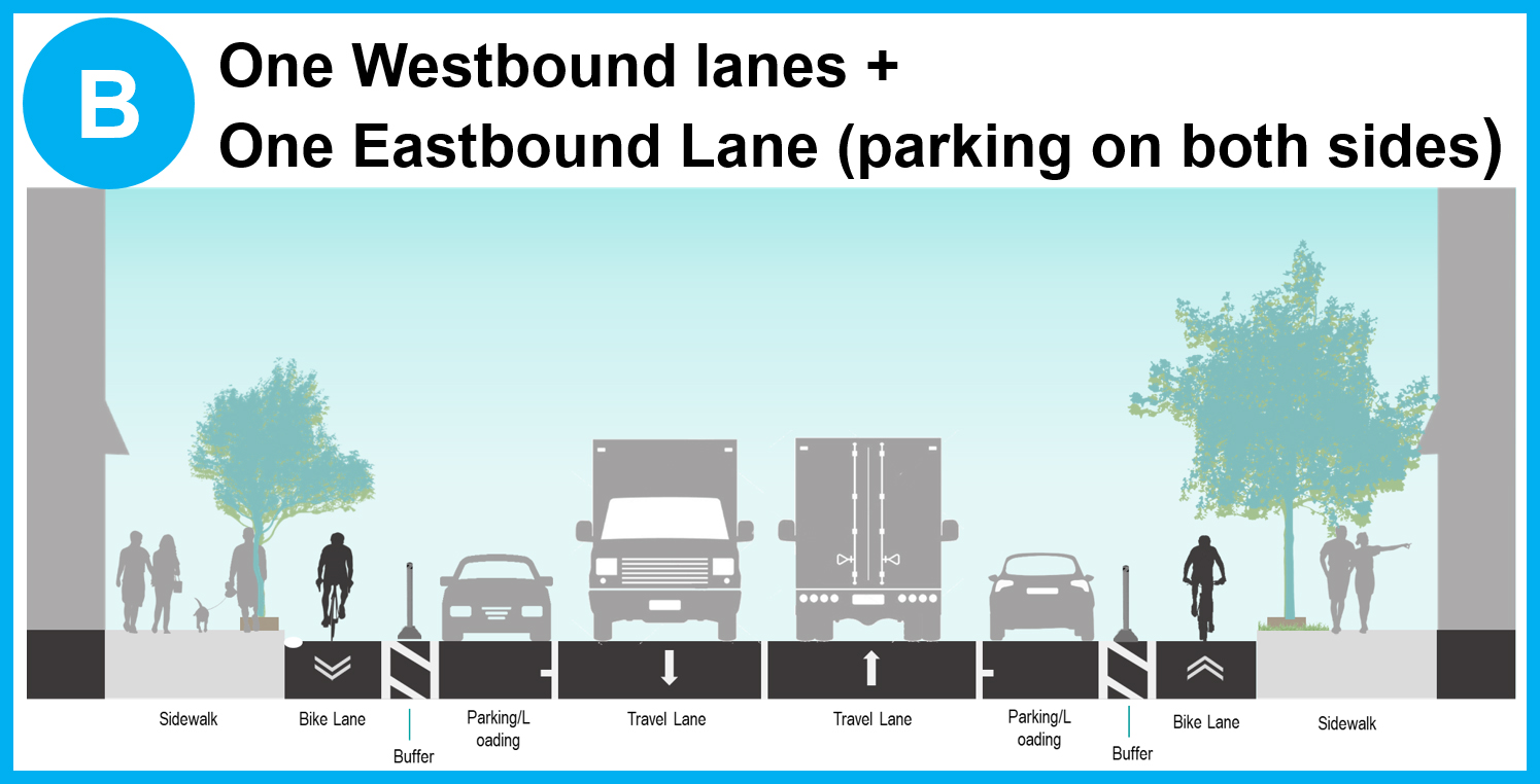
Cross-section for Caledonia Road and Oakwood Avenue.
The changes for the section between Caledonia Road to Oakwood Avenue included:
One-way cycle tracks with various buffer treatments. New north-south contra-flow bike lanes on Jimmy Wisdom Way.
One westbound motor vehicle lane and one eastbound motor vehicle lane. Lane configuration at intersections varies.
Consideration for traffic signal upgrades at Eglinton Avenue/Northcliffe Boulevard/Jimmy Wisdom Way. Signal upgrades and signal timing changes at various locations, including bike signal heads and leading pedestrian interval.
Proposed 24/7 parking on both sides of the street between Caledonia Road and Glenholme Avenue. Proposed 24/7 parking on the south side of Eglinton Avenue between Glenholme Avenue and Oakwood Avenue.
Dufferin Street intersection and streetscape improvements, including raised cycle tracks constructed by Metrolinx/Crosslinx as part of the Eglinton Crosstown LRT.
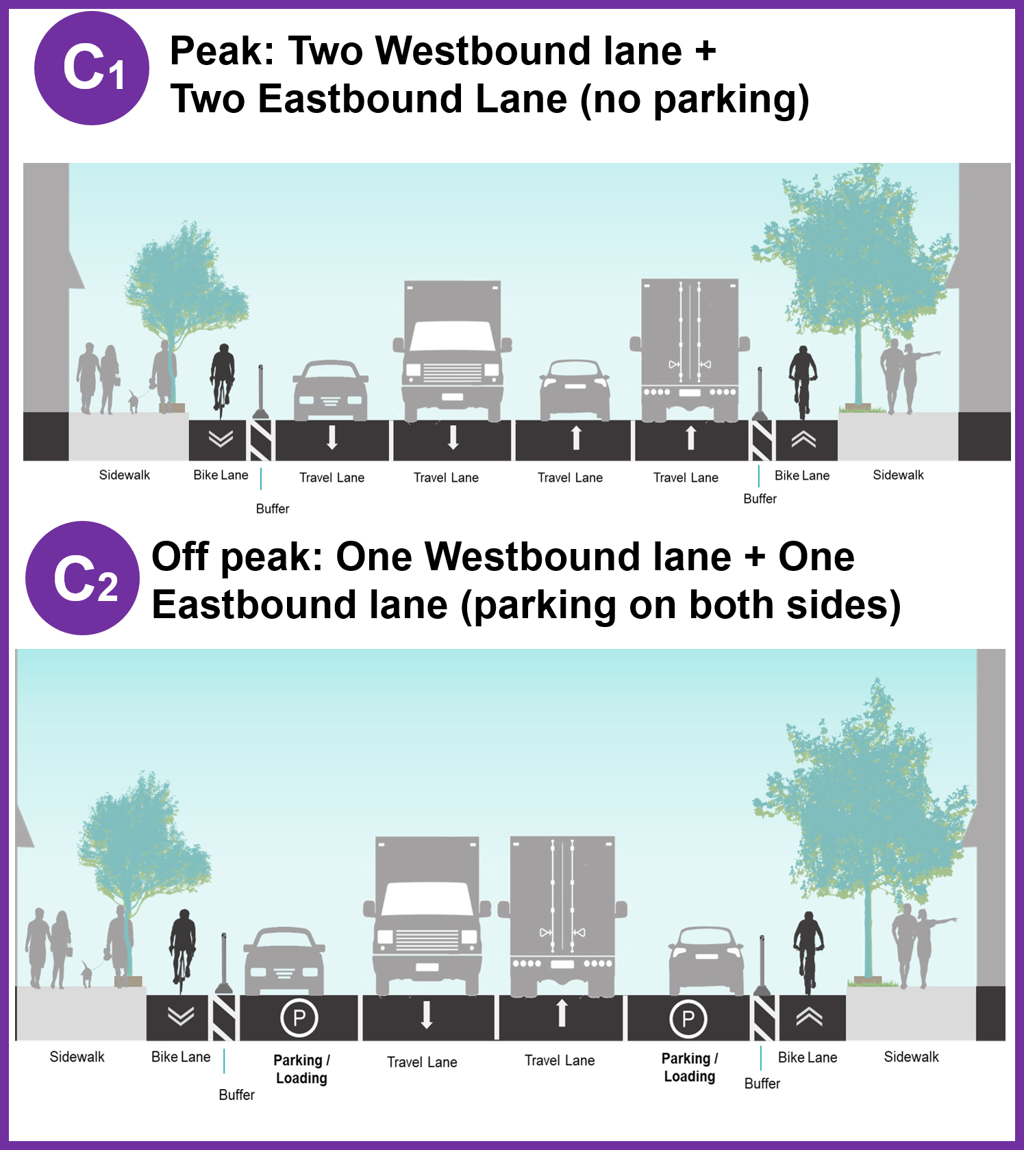
Cross-sections for Oakwood Avenue and Spadina Avenue.
The changes for the section between Oakwood Avenue to Spadina Avenue included:
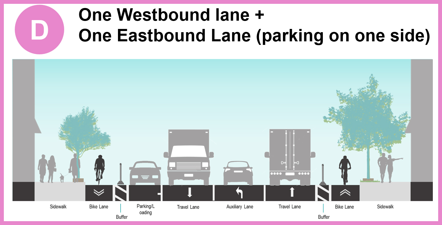
One-way cycle tracks with various buffer treatments. New north-south contra-flow bike lanes on Glen Cedar Road.
Two westbound motor vehicle lanes and two eastbound motor vehicle lanes during peak hours (7-9 a.m.; 4-6 p.m. Monday to Friday). Lane configuration at intersections varies.
Consideration for traffic signal upgrades at Eglinton Avenue/Marlee Avenue/Winona Drive. Signal upgrades and signal timing changes at various locations, including bike signal heads and leading pedestrian interval.
Off peak parking on both sides of the street and afternoon peak hour parking will be permitted on the south side of Eglinton Avenue between Westover Hill Road and Peveril Hill Road.
Section between Parkhill Road and Flanders Road, including the Allen Road interchange, accommodates additional turning lanes.
Cross-section Spadina Avenue and Mount Pleasant Road.
The changes for the section between Spadina Avenue to Mount Pleasant Road included:
One-way cycle tracks with various buffer treatments.
One westbound motor vehicle lane and one eastbound motor vehicle lane. Lane configuration at intersections varies.
Signal upgrades and signal timing changes at various locations, including bike signal heads and leading pedestrian interval.
Proposed 24/7 parking on one side of the street (alternating north and south).
Chaplin Crescent intersection, Mount Pleasant Road intersection, and section between Avenue Road and Holly Street, including the Yonge Street intersection, constructed by Metrolinx/Crosslinx as part of the Eglinton Crosstown LRT construction.
Changes for Croham Road, Glen Cedar Road and Jimmy Wisdom Way were identified in the Council-adopted Cycling Network Plan as north-south connections to and across Eglinton Avenue. The changes included:
Creating a safe and comfortable corridor for people travelling by foot and bicycle, while encouraging active transportation for short neighbourhood trips
Minimizing impacts to on-street parking and maintaining local access for people driving
Maintaining City services, including fire, emergency medical services, solid waste collection, snow clearing and local access, with no impacts to existing sidewalks, or traffic flow
These north-south connecting routes will be deferred along with the eglintonTOday Complete Street project.
Croham Road
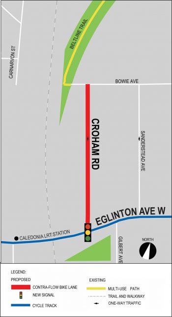
The changes for Croham Road between Eglinton Avenue and Bowie Avenue included contra-flow bike lanes that would expand the local cycling network and connect to Eglinton Avenue, the York Beltline Trail and the new Caledonia LRT station. Details included:
Project Area
Croham Road Contra-flow Bike Lane
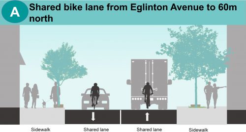
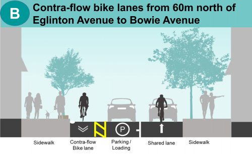
Cross-sections for Crowham Road between Eglinton Avenue to Bowie Avenue.
What Would This Change Mean for You?
If you drive or park on the street:
Parking will continue to be allowed on the west side of the street. A reduction of six on-street parking spaces is anticipated.
Once the development at 9 Croham Road is completed, the first 60 metres of Croham Road north of Eglinton Avenue will accommodate two-way traffic to the building’s entrance. For this section, northbound and southbound vehicular traffic will share the road with people cycling.
For the section north of 9 Croham Road, northbound vehicular traffic will share the road with people cycling.
No stopping is permitted in contra-flow bike lanes.
A new traffic signal is being considered at the intersection of Eglinton Avenue and Croham Road.
All other turning movements, laneway and driveway access would remain.
If you cycle:
You would be able to travel both north and south on Croham Road, making it easier and more comfortable to connect to other cycling facilities, parks and trails in the area.
A new traffic signal with bike signal heads and other accessibility enhancements are being considered at the intersection of Eglinton Avenue and Croham Road to improve safety and connectivity for pedestrians and people cycling.
The proposed contra-flow bike lane on Croham Road will connect to Eglinton Avenue and the York Beltline Trail.
Glen Cedar Road
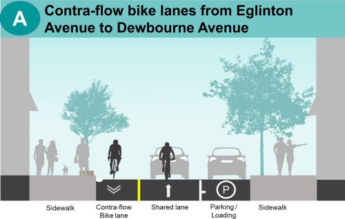
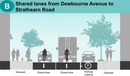
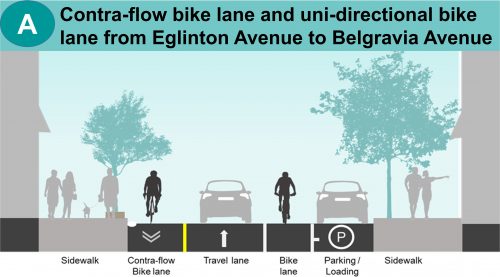
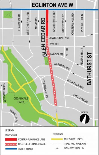
The changes for Glen Cedar Road between Eglinton Avenue and Strathearn Road included contra-flow bike lanes on the one-way section of Glen Cedar Road and installation of shared bike lanes for the two-way section of Glen Cedar Road that would expand the local cycling network to connect Eglinton Avenue to important cycle routes south of Cedarvale Ravine. Design changes also considered maintaining the current two turning lanes at the North end of Glen Cedar Road. Details included:
Project Area
Glen Cedar Road Contra-flow Bike Lane
Cross-sections for Glen Cedar Road between Eglinton Avenue and Strathearn Road.
What Would This Change Mean for You?
If you drive or park on the street:
No changes to parking on Glen Cedar Road. Parking will continue to be allowed on the east side of the street.
For the one-way section of Glen Cedar Road between Eglinton Avenue and Dewbourne Avenue, northbound vehicular traffic will share the road with people cycling.
For the two-way section of Glen Cedar, between Dewbourne Avenue and Strathearn Road, northbound and southbound vehicular traffic will share the road with people cycling.
No stopping is permitted in contra-flow bike lanes.
At the intersection of Eglinton Avenue and Glen Cedar Road, two turning lanes will be maintained to accommodate a shared through/left lane and a dedicated right turn lane.
All other turning movements, laneway and driveway access would remain.
No other traffic impacts to the way the streets operate when you drive.
If you cycle:
You would be able to travel both north and south on Glen Cedar Road, making it easier and more comfortable to connect to other cycling facilities, parks and trails in the area.
The proposed contra-flow bike lane on Glen Cedar Road will connect Eglinton Avenue and Cedarvale Ravine.
Jimmy Wisdom Way
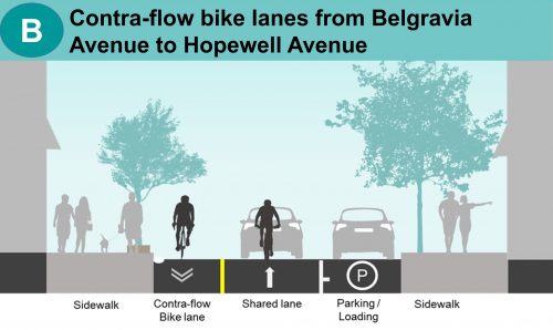
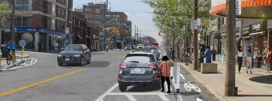
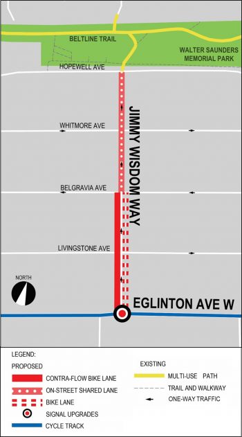
The changes for Jimmy Wisdom Way between Eglinton Avenue and Hopewell Avenue include contra-flow bike lanes, and upgrades at the signalized intersection at Eglinton Avenue and Northcliffe Boulevard that would expand the local cycling network and connect to Eglinton Avenue, and the York Beltline Trail. Details included:
Project Area
Jimmy Wisdom Way Contra-flow Bike Lane
What Would This Change Mean for You?
If you drive or park on the street
No changes to parking on Jimmy Wisdom Way. Parking will continue to be allowed on the east side of the street.
For the section of Jimmy Wisdom Way between Belgravia Avenue and Hopewell Avenue, northbound vehicular traffic will share the road with people cycling.
No stopping is permitted in bike lanes.
Traffic signal upgrades are being planned at the intersection of Eglinton Avenue and Northcliffe Boulevard to incorporate Jimmy Wisdom Way into the intersection.
All other turning movements, laneway and driveway access would remain.
No other traffic impacts to the way the streets operate when you drive.
If you cycle:
You would be able to travel both north and south on Jimmy Wisdom Way, making it easier and more comfortable to connect to other cycling facilities, parks and trails in the area.
Bike signal heads and other accessibility enhancements are being considered at the intersection of Eglinton Avenue/Northcliffe Boulevard/Jimmy Wisdom Way to improve safety and connectivity for pedestrians and people cycling.
The proposed contra-flow bike lane on Jimmy Wisdom Way will connect to Eglinton Avenue and the York Beltline Trail.
Public Consultation
City Council Approval
City Council authorized the installation of the proposed complete street, including bikeways, on Eglinton Avenue between Bicknell Avenue and Mount Pleasant Road on May 22, 2024 (Item IE13.2). A portion of the project, between Chaplin Crescent and Avenue Road, was installed in fall 2024.
Installation of the remainder of the project was planned to commence in summer 2025. However, due to ongoing delays to the opening of the Eglinton Crosstown LRT (ECLRT), Council directed Transportation Services to identify an implementation timeline that aligned with the ECLRT opening and minimized traffic impacts associated with construction and the continued operation of TTC surface bus routes.
The City is currently unable to complete installation of the remaining project elements due to changes to the Provincial Highway Traffic Act.
Design Highlights
Lane Configuration Changes
The project proposed to implement complete street features including cycle tracks, curb extensions, pedestrian head start signals, and public realm upgrades on Eglinton Avenue between Bicknell Avenue and Mount Pleasant Road by reassigning some of the existing vehicular space to accommodate parking, bikeways, seasonal patio extensions, and other complete street features, and to fit within the existing curb to curb space:
Between Bicknell Avenue and Caledonia Road, two westbound motor vehicle lanes and one eastbound motor vehicle lane are proposed to be maintained, generally with on-street parking on one side.
Between Caledonia Road and Oakwood Avenue, one motor vehicle lane in each direction are proposed to be maintained with parking on both sides.
Between Oakwood Avenue and Spadina Road, two westbound and two eastbound motor vehicle lanes are proposed to be maintained in the peak hours, with off-peak parking allowed in both curb lanes.
Between Spadina Road and Mount Pleasant Road, one westbound and one eastbound motor vehicle lane with parking on one side is proposed to be maintained to match the Metrolinx delivered section between Yonge Street and Avenue Road.
Parking Changes
Based on feedback from the BIAs and local businesses, parking was been prioritized within commercial areas. There are currently 366 pay and display parking spaces along Eglinton Avenue from Bicknell Avenue to Mount Pleasant Road.
A total of approximately 531 pay and display parking spaces have been proposed through the designs, with approximately 313 of these parking spaces converted from current off-peak only restrictions to full-time parking.
Connecting North-South Cycling Routes
Three north-south cycling connections are also proposed to connect to the Beltline and other existing cycling routes:
Croham Road from Eglinton Avenue West to Bowie Avenue – contra-flow bike lanes with no impact on parking
Glen Cedar Road from Eglinton Avenue West to Dewbourne Avenue – contra-flow bike lane with the two existing motor vehicle lanes at Eglinton maintained and no impact on parking
Jimmy Wisdom Way from Eglinton Avenue West to Hopewell Avenue – bicycle lanes and contra-flow bike lanes with the resultant removal of six parking spaces
Stakeholder Advisory Group (SAG)
The eglintonTOday SAG was formed fall 2023 to provide feedback, guidance, and advice to the City Project Team on the development of the Data Collection & Monitoring Plan and the identification of potential design modifications to the Complete Street design in response to issues that may arise after installation.
Eglinton Connects was a comprehensive Planning Study undertaken from 2012 to 2014, with final Decisions of the Tribunal by 2018. The resulting Eglinton Connects Plan included a redesign of the streetscape along the Crosstown corridor through an Environmental Assessment. The streetscape redesign and Eglinton Connects Plan, including cycle tracks, was to be implemented through streetscape updates via the Crosstown construction, including:
At the frontages of nine stations on the 11 km underground portion of the LRT between Black Creek Drive and Brentcliffe Road
A multi-use path between Mount Dennis station and Black Creek Drive
The section between Avenue Road and Holly Street
The above ground section east of Brentcliffe Road
From 2017 to 2019, a detailed analysis was undertaken regarding the property-specific implications of implementation of the Eglinton Connects streetscape. For example, there are existing encroachments in the right of way, such as stairs, ramps, gardens, and walls. Rather than impacting property owners at significant expense to the City, staff determined it would be best to achieve the overall Eglinton Connects streetscape over the longer term (e.g. in part through redevelopment) and through less invasive measures.
In December 2019, City Council directed staff to develop a strategy to accelerate design work of streetscape improvements along Eglinton Avenue, including cycle tracks, to align with the opening of the Eglinton Crosstown LRT. The eglintonTOday Complete Street project included quick and actionable changes that can transform Eglinton Avenue into a complete street that would support and complement the transit corridor. This would also achieve the intent of the Eglinton Connects streetscape, with the full streetscape to be achieved over the long term.
The Federal Government provided funding for the Eglinton Connects Streetscape and Cycle Track project though the Public Transit Infrastructure Fund (PTIF).

While we aim to provide fully accessible content, there is no text alternative available for some of the content on this page. If you require alternate formats or need assistance understanding our maps, drawings or any other content, please contact us at 416-338-7755 or email eglintonTOday@toronto.ca.