City Council has approved the installation of road safety improvements on Horner Avenue between Westhead Road and Brown’s Line and Foch Avenue from Horner Avenue to Edgeware Drive. A copy of the staff report is available at IE30.2.
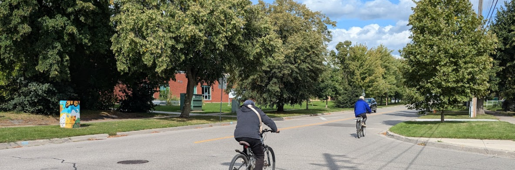
The City is installing cycling and road safety upgrades on Horner Avenue and Foch Avenue to improve safety for all road users.
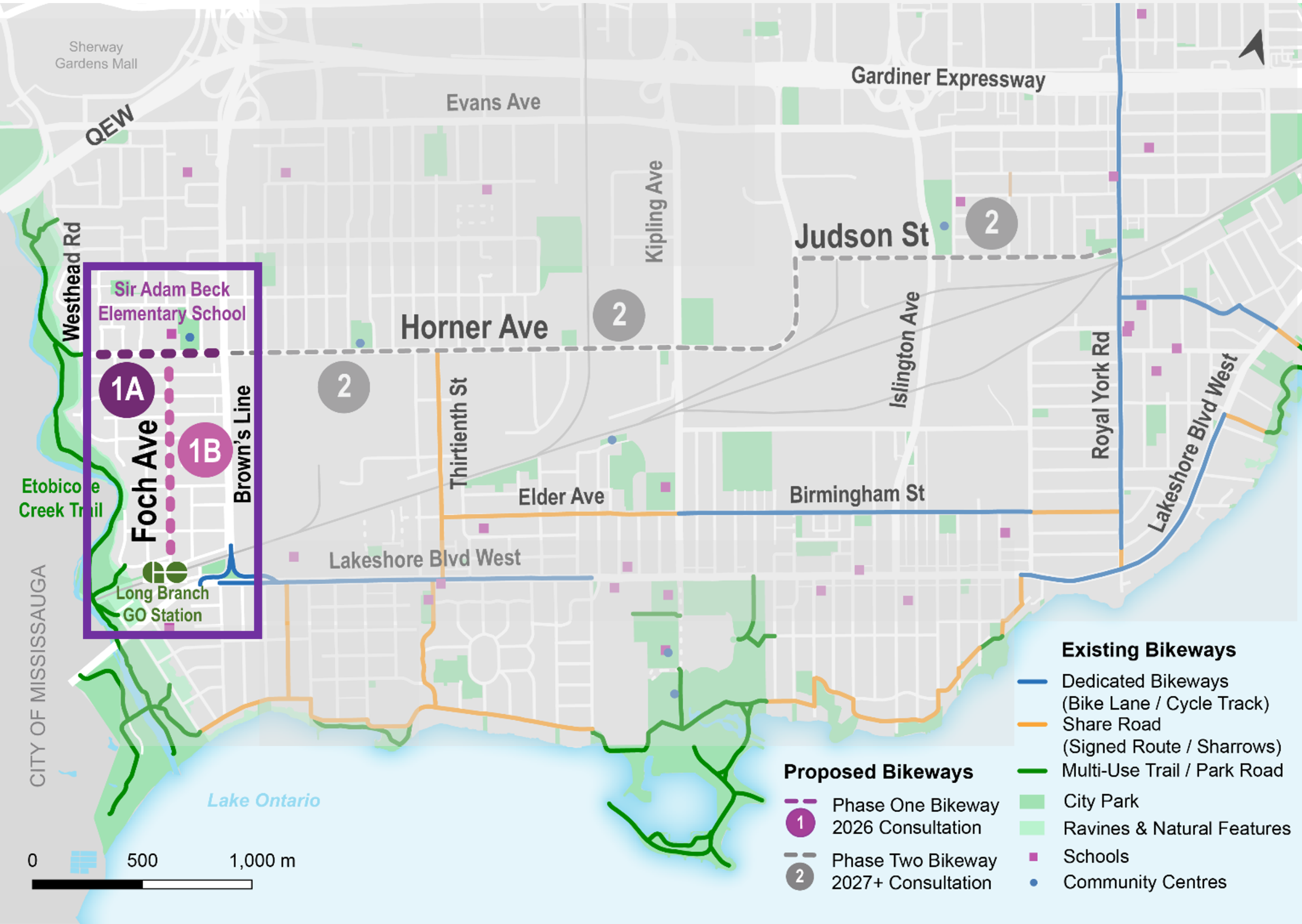
The proposed changes are being designed and consulted on in two phases. Phase 1 changes for Horner Avenue from Westhead Road to Brown’s Line, and Foch Avenue from Horner Avenue to Edgeware Drive have been approved for installation. Improvements will maintain motor vehicle lanes while slowing the speed of cars through traffic calming and the addition of bike lanes and shared lane markings. The bikeways will connect the Etobicoke Creek Trail, Sir Adam Beck School, Alderwood Pool and Library, residences, churches, and the Long Branch GO Station. Consultation on Phase 2 changes for Horner Avenue east of Brown’s Line is anticipated for 2027.
Project Area
Public consultation and installation for the Horner Avenue Road Safety Improvements will take place over two phases described below.
Phase 1 (2026): Horner Avenue between Westhead Road and Brown’s Line, and Foch Avenue between Horner Avenue and Edgeware Drive (approved June 2026)
Phase 2 (2027+): Horner Avenue and Judson Street, from Brown’s Line to Royal York Road.
Installation for both phases: 2028+
Public consultation for Phase 2 is anticipated as early as 2027, at which time further details about proposed design changes, reporting and implementation schedule will be available.
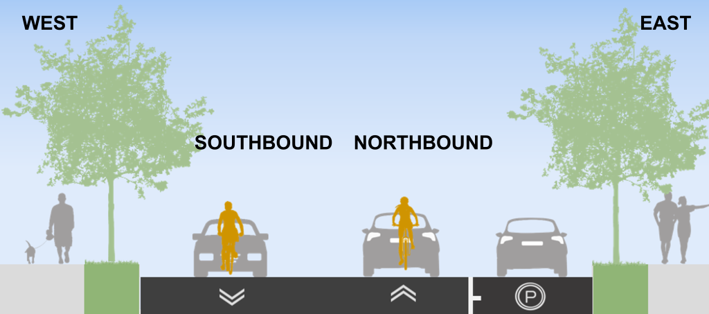
Phase 1A Approved Changes: Horner Avenue from Westhead Road to Brown’s Line
Install painted bike lanes and wayfinding signage on both sides of the street
Narrow travel lanes to 3.3 metres to meet the City’s standard lane widths
Reduce speed limit to 30 km/h
Install four speed humps between Delma Drive and Orianna Drive for traffic calming
Prohibit parking on both sides of the street at all times with the exception of two spots on the north side of Horner Avenue between Brown’s Line and Orianna Drive
Install impressed asphalt at the intersection of Westhead Road, Horner Avenue, and the Etobicoke Creek Trail entrance to draw attention to the existing stop
control and the crossing movements of trail users
No change to the number of motor vehicle lanes
No change to City maintenance and operations
Maintain driveway access to properties
Maintain left turn lane at Brown’s Line
Phase 1B Approved Changes: Foch Avenue from Horner Avenue to Edgeware Drive
Install shared lane markings (sharrows) and wayfinding signage on both sides of the street
Install pavement markings for pedestrian crosswalks at existing stop signs and to mark locations for “No Parking” close to side streets to improve sightlines
No change to parking
No change to the number of motor vehicle lanes
No change to City maintenance and operations
Maintain driveway access to properties
There will be no bike lanes, change to motor vehicle lanes or change to the existingparking rules.
The Ward Councillor will conduct additional consultation on potential speed humps for Foch Avenue, and would require approval in a future report. Staff will also investigate the feasibility of additional safety improvements to the pedestrian crossing at the intersection of Horner Avenue and Foch Avenue, such as raised pedestrian crossings.
Public Consultation
The comment period for Phase 1 of consultation has closed. The Public Consultation Report summarizes feedback received.
Public feedback, along with technical and policy considerations, informs staff recommendations and decisions made by City Council.
Public Drop-In Event
The Public Drop-In Event for Phase 1 took place on February 2, 2026 at Alderwood Community Centre. It provided an opportunity to view the project information panels and speak with members of the project team one-on-one.
Feedback
A feedback survey on Phase 1 of this project was conducted from January 19 to February 13, 2026.
The City reviewed all the feedback submitted during Phase 1 public consultation, and a copy of the Public Consultation Report is now available.
Below is a summary of the concerns participants raised and how the City responded, including changes made to the initial proposed design based on public input and technical and policy considerations.
Safety of narrower vehicle travel lanes on Horner Ave
Design was amended to 3.3 metres for the motor vehicle travel lanes (instead of 3 metres), supported by the City’s design guidelines
Both 3 and 3.3 metre lane widths can accommodate large vehicles and emergency vehicles but 3.3 metres is more comfortable while still encouraging lower speeds of travel
Impact and effectiveness of speed humps
Traffic calming was recommended to reduce speeds on both Horner Avenue and Foch Avenue to improve safety for children and pedestrians and people cycling
Speed humps are designed in a way that people driving at 30 km/h or slower will not experience discomfort
The standard height of a speed hump is 75 millimeters. This height was established following consideration of the expressed concerns of Emergency Services who stated that speed humps taller than 75 millimeters would cause significant delays in their response time
Note: in June 2026 Council approved four speed humps between Delma Drive and Orianna Drive on Horner Avenue. Ward Councillor will conduct further consultation on Foch Avenue speed humps prior to approval.
Removal of unsigned on-street parking along Horner Avenue
Data collection and consultation with leaders of organizations along Horner Avenue confirmed low utilization of Horner Avenue for parking
Designs were adjusted to accommodate two on-street parking spots on the north side of Horner Avenue between Orianna Drive and Brown’s Line (the location in highest demand) while maintaining the painted bike lane
Safety along Foch Avenue
Curb extension added on Foch Avenue at Horner Avenue to further slow traffic and provide more space for pedestrians near this important crosswalk location
Pavement markings and signage added on Foch Avenue to designate no parking within 9 metres of side streets to improve sight lines for vehicles and safety
Safety at the Etobicoke Creek Trail entrance at Westhead Road and Horner Avenue
One speed hump recommended on Westhead Road on the approach to the stop sign near the trail entrance to help enforce slow speeds and stopping
Additional consultation is being conducted by the Councillor’s office about whether the community would like more speed humps along Westhead Road
Impressed (stamped) asphalt treatment added at the intersection of Westhead Road, Horner Avenue, and the trail entrance to further slow traffic and draw attention to this unique intersection with many pedestrian and cycling movements
Safety improvements at Horner Avenue and Brown’s Line
Requests will be explored as part of Phase 2 of work which will cover Horner Avenue east of Brown’s Line
Requests for further speed humps or stop signs
Requests require additional traffic studies in the spring and will be revisited in Phase 2
Install a roundabout or traffic circle at Foch Avenue and Horner Avenue
Staff conducted initial feasibility review and determined both options would not be feasible without property impacts and significant reconstruction, and would have a negative effect on the safety of pedestrians crossing at this intersection.
Review this feasibility summary for more information, and contact the project team for questions or additional details.
Requests to not proceed with bike lane and shared lane markings
Staff recommended proceeding with bike lanes and shared lane markings to improve safety and provide an important connection to future planned bikeways along Brown’s Line east of Horner Avenue, to the Etobicoke Creek Trail and to the Long Branch GO Station. This is in alignment with the City’s Vision Zero policy.
The lack of lane removal and low parking utilization along Horner Avenue presents minimal impacts to traffic operations.
Background
The City Council-approved Cycling Network Plan is a comprehensive roadmap and work plan that outlines the City’s planned investment in our cycling network. It includes a Long-Term Cycling Network Vision, the planned Major City-Wide Cycling Network Routes, and a three-year rolling Near-Term Implementation Program.
The aim of the Cycling Network Plan is to connect gaps in Toronto’s current cycling network, grow the network into new parts of the city, and upgrade existing cycling routes to improve safety and comfort for all road users.
Horner Avenue is identified as a proposed cycling route in the Plan for study and design in the near-term.
To receive project updates by email, pleasecontact usandindicatethat you would like to be added to the mailing list.