The Portland-Dan Leckie bikeway is in the process of being installed. Please ride with caution. The southbound bikeway will open once the signals are updated and the final block of the bikeway between Lakeshore Boulevard and Queens Quay are complete in the coming weeks. View the Installation Notice for more details.

The City of Toronto is proposing a new bikeway that will connect Queen Street West to Queens Quay West. This new cycling route will run along Portland Street – across the Puente De Luz pedestrian/cycling bridge – and down Dan Leckie Way. This project is part of the Council-approved Cycling Network Plan for 2024 and will provide a safe cycling route connecting our City’s waterfront with the bustling and rapidly growing fashion district. It will also provide traffic calming measures and reduce neighbourhood traffic infiltration.

Project Goals:

  • Provide a safe and comfortable alternative to cycling on Spadina Avenue and Bathurst Avenue.
  • Connect major east-west cycling routes from Queen Street to Queens Quay West.
  • Improve the public realm and pedestrian experience in a densifying neighbourhood.

October 2024

The portion of the Portland-Dan Leckie bikeway on Dan Leckie Way from Queen’s Wharf Road to Fort York Boulevard, is planned for installation starting October 14th, 2024. Construction notice can be seen here. Installation Notice

Key changes include:

  • Installation of a bi-directional (two-way) protected cycle track on the east side of Dan Leckie Way from Queen’s Warf Road to Queen’s Quay.
  • Removal of 8 parking spots on the east side of Dan Leckie Way between Fort York Boulevard and Queen’s Warf Road.
  • Relocation of the northbound school bus stop from the east side of Dan Leckie Way to southbound on the west side (directly across the street). Parents and students will be informed through TDSB and signage. Students will cross at the crosswalk at the all-way stop signs.
  • Introduction of painted bicycle turn boxes at Fort York Boulevard and at Queen’s Quay.
  • Minor adjustments to motor vehicle lane widths and traffic signals.

Three concrete sidewalks support the bikeway were completed in August 2024. The portion of the bikeway on Portland Street is planned to be installed in 2025 to accommodate the construction of the King/Bathurst Ontario Line Station.

July 2024

The full project was originally planned for installation in 2024. In order to better accommodate active construction for the Ontario Line King/Bathurst Station, installation of the Portland Street segment of the project will be postponed until 2025.

The City continues to work with Metrolinx and Deputy Mayor Malik’s office to minimize the impacts of the Ontario Line construction on the community. This delay also means that establishments on Portland Street with CafeTO patios will be able to make full use of the 2024 season.

The Dan-Leckie section of the project is still planned for installation in 2024 and an installation notice will be mailed to all local addresses in advance with anticipated dates, impacts and details.

Some associated sidewalk work to accommodate cycling ramps will begin in August at the following locations:

  • The north end of Dan Leckie at Iceboat Terrace to build curb depressions to connect by bike to the Puente de Luz Bridge
  • On the Northeast corner of Dan Leckie Way and Lakeshore Blvd to build the bike ramps to create a safe crossing from the sidewalk level
  • At Dan Leckie Way and Queen’s Quay to remove the traffic island to accommodate the new lane configuration

Installation Notice 

January 2024

Based on public feedback, the project team updated the cycle track design. These updates were shared at a virtual public meeting on Tuesday, January 23rd (6:30 – 8 p.m.).
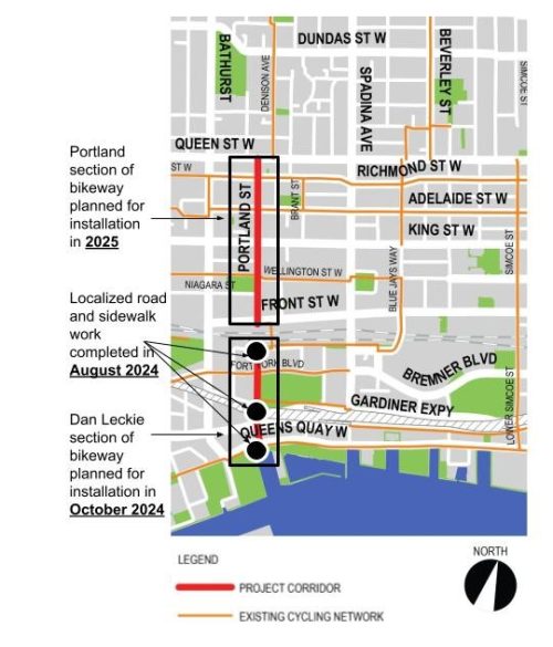
Map of downtown Toronto from the waterfront to north of Queen Street and from Lower Simcoe to Strachen Avenue. The map describes the existing cycling network, programmed cycling network and the project corridor along Portland Street, across the Puente de Luz bridge and down Dan Leckie Way.

The project area extends along Portland Street from Queen Street to Front Street, across the Puente de Luz Bridge, and along Dan Leckie Way from Queens Wharf Road to the Martin Goodman Trail.

Following public consultation, the design for this segment has been revised. Please see Project Updates above.
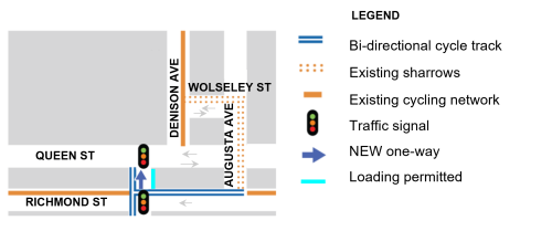
Map of Proposed Changes on Richmond Street from Augusta Avenue to Portland Street - Updated

In this section the City is proposing:

  • Existing shared lane markings on Augusta Avenue will direct cyclists from Richmond Street to the existing Denison Avenue Bikeway north of Queen Street at a signalized crossing
  • No change to traffic flow or parking on this street
  • No loss of parking

Following public consultation, the design for this segment has been revised. Please see Project Updates above.
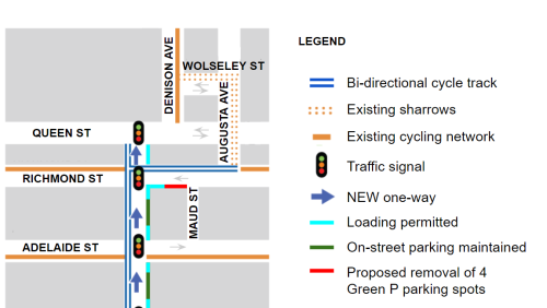
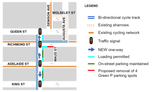
Map of project area

In this section the City is proposing:

  • Turn the existing westbound bike lane on the north side of Richmond Street into a two-way bike lane to provide access to safe crossing of Queen Street at the Augusta Avenue traffic signal
  • Four Green P paid parking space on the South side of Richmond Street West of Maud Street are proposed to be removed

Following public consultation, the design for this segment has been revised. Please see Project Updates above.
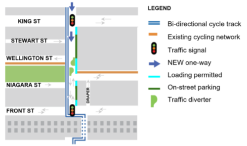
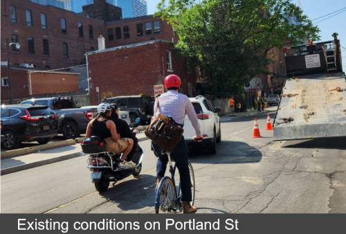
Map of proposed changes from Queen Street to King Street Portland street. A person is biking next to a scooter and behind a car. All vehicles are going around a semi-trailer truck parked on the right-hand side of the street. Text band across the bottom of the image reads “existing conditions on Portland

In this section the City is proposing:

  • Install a protected two-way bike lane on the west side of the street
  • Portland Street is proposed to be converted from a two-way street to a one-way street northbound from King Street to Queen Street
  • No loss of parking

Following public consultation, the design for this segment has been revised. Please see Project Updates above.
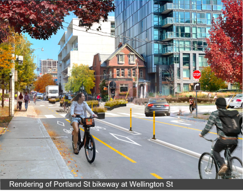
Map of proposed changes from King Street to Front Street West Artistic rendering of the proposed bikeway at Portland and Wellington. Cycle track runs along the west side of the street. Planters act as a traffic diverter at the centre of the intersection. Text band across the bottom of the image reads “Rendering of Portland St bikeway at Wellington St”

In this section the City is proposing:

  • Install a protected two-way bike lane on the west side of the street
  • Convert from a two-way street into a one-way street south-bound, between King Street West to Front Street West
  • Install a traffic diverter at Wellington Street and Portland Street to minimize neighbourhood traffic infiltration and intersection conflicts

The block of Portland Street from Niagara Street to Front Street is under consideration for conversion to a one-way street southbound. This option would allow the addition of on-street parking and loading zones.

Following public consultation, the design for this segment has been revised. Please see Project Updates above.
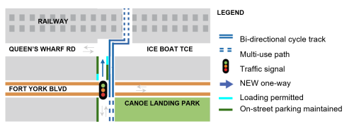
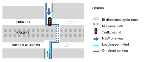
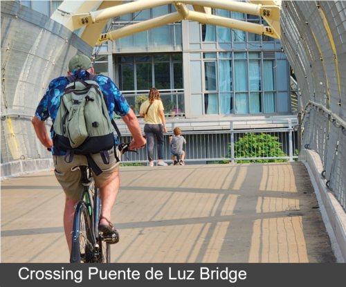
Map of proposed changes on the Puente de Luz Bridge Person biking crosses the Puente de Luz Bridge. Text band across the bottom of the image reads “Crossing Puente de Luz Bridge”

The bridge will connect the north and south segments of the Portland – Dan Leckie bikeway. Cyclists must yield to pedestrians while crossing the bridge.

Following public consultation, the design for this segment has been revised. Please see Project Updates above.
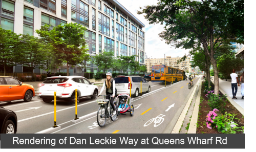
Map of proposed changes on Dan Leckie Way from Queens Wharf Road to Fort York BoulevardImage of cyclist on two-way cycle track

In this section the City is proposing:

  • Install a two-way bike lane on the east side of the street, between the parking and the sidewalk
  • Convert to a one-way street; both northbound and southbound directions are under consideration
  • Parking spaces currently in the east curb lane will be moved to the curb of the protected bike lane
  • No change to parking and loading on the west side of street

Following public consultation, the design for this segment has been revised. Please see Project Updates above.

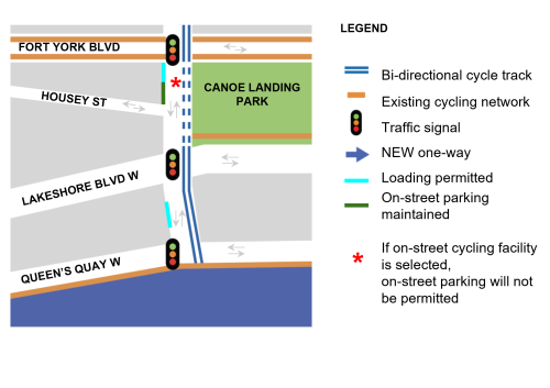
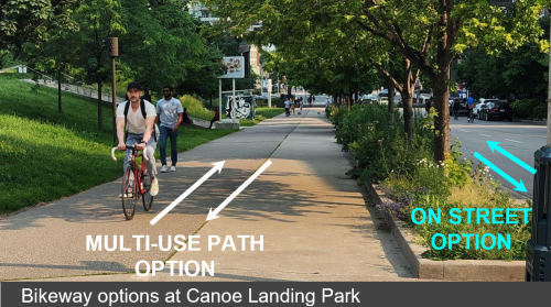
Map of proposed changes on Dan Leckie Way from Fort York Boulevard to Queen’s Quay. Multi use pathway next to Canoe Landing Park. Text and arrows describe both proposed options: 1 – bikeway on multi-use path along the park or 2 – bikeway on the street.

There are two options under consideration for the bikeway from Fort York Boulevard to Lake Shore Boulevard:

Option 1 – share existing multi-use path

  • The bikeway can share the existing multi-use path along the west edge of Canoe Landing Park with lane markings to direct cycling and pedestrians traveling at different speeds

Option 2 – continue on-street (Dan Leckie Way)

  • The two-way bikeway could continue on the east side of the roadway on Dan Leckie Way if feasible.
  • This option would result in a loss of four existing paid parking spots.

Please note that the the formal consultation period is now closed.

Virtual Public Meeting

The City of Toronto invited community members to a virtual meeting on January 23rd, 2024 learn about how the design was updated based on community feedback. Attendees had the opportunity watch a presentation and ask the project team questions.

Public Consultation 

The City of Toronto invited residents to a public Drop-In event on October 16, 2023 to learn more about the project and provide feedback about the proposed changes on Portland Street and Dan leckie Way.

Attendees had the opportunity to view the project information panels and speak with members of the project team one-on-one.

A survey received 1300 + responses.

Insights from the survey and all consultation events can be found in the consultation report:

Next Steps

The project team will present proposed design to the Infrastructure and Environment Committee of City Council in March 2024 for approval of the project. Subject to approval, installation is planned for 2024.

Stay Informed

Sign-up to receive project updates by email.