A Road Safety Improvement Project
The Sandhurst Circle Neighbourhood Connections project aims to improve road safety on Sandhurst Circle, Brimwood Boulevard, Chartland Boulevard South, Dibgate Boulevard, and White Heather Boulevard for all road users, including people walking and cycling by:
- Installing bikeways and safer road crossings, with no changes to the number of motor vehicle lanes
- Creating a local cycling network with connections to the Finch Corridor Trail, East Highland Creek Trail, local destinations including schools, Woodside Square Mall, public transit, parks and the Alton Towers area.
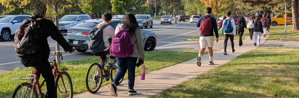
These road safety improvements would serve six school zones and an area with a history of many traffic collisions. From 2015 to 2025, 510 reported collisions occurred on these roads. Of these collisions, 42 involved people walking or cycling, including two fatalities, one involving a high school student, and two serious injuries.
News & Updates
June 2026 – Project Update
In response to feedback, the proposed designs have been revised as of May 2026. To accommodate the revised designs, installation plans are delayed. Project updates will be shared with the public for feedback before proposed designs are recommended to City Council in 2027.
June 2026 – Community Event
The Sandhurst Circle Neighbourhood Connections project team held a free community drop-in event open to children and youth in the community 4 – 18 years old and welcomed riders of all skill levels. Participants had the opportunity to enjoy a variety of fun and engaging activities including free bike checks, skill-building bike stations and bike decorating.
Project Area
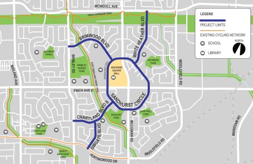
Sandhurst Circle Neighbourhood Connections extends along Sandhurst Circle, Brimwood Boulevard, Chartland Boulevard South, Dibgate Boulevard and White Heather Boulevard.
Response to Feedback
The City considers potential changes to proposed designs through review of feedback from community representatives, businesses and the public, alongside technical information, policies, guidelines and site observations.
Below is a summary of key concerns raised by participants and how the City is responding, including changes to proposed designs along with a map showing the updated designs.
Concerns about parking removal:
- Updated designs for Brimwood Boulevard, Chartland Boulevard South, Dibgate Boulevard, and White Heather Boulevard keep sections of on-street parking, including drop-off / pick-up spaces in front of schools.
Concerns about changes to motor vehicle lanes and changes to directions of motor vehicle travel:
- Updated designs maintain all existing motor vehicle lanes, including left-turn lanes on Sandhurst Circle and both travel lanes on Chartland Boulevard South. The updated design does not include the proposed one-way conversion on Chartland Boulevard South.
Concerns about narrower vehicle lanes and winter maintenance:
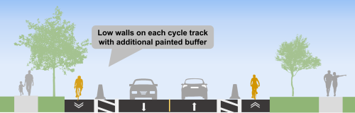
- Updated designs follow the City’s standard lane width guidelines and meet the needs of large vehicles including buses and trucks. On Sandhurst Circle the updated design includes additional buffer space between low wall barriers and vehicle lanes which provides space for snow storage and large vehicles.
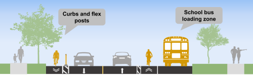
Concerns about changes to school bus loading zones and school drop-off / pick-up spaces for caregivers:
- Updated designs keep existing school bus loading zones at the curb. There are no locations where students exiting a school bus cross a bikeway. The updated designs keep sections where caregivers can drop-off and pick-up students.
Concerns about protection for people cycling on Brimwood Boulevard, Chartland Boulevard South, Dibgate Boulevard, and White Heather Boulevard:
- Updated designs include a painted buffer between the bike lane and motor vehicle lanes. There may be opportunity to upgrade some sections of the painted buffer with physical separation in future years.
Requests for additional safety improvements, especially pedestrian crossings:
- Staff are reviewing additional changes at three locations where new traffic counts and warrant analyses must be completed:
- Additional improvements to the East Highland Creek Trail crossings of Brimwood Boulevard and Chartland Boulevard South
- Potential all-way stop at Dibgate Boulevard and Chartland Boulevard South
- Potential new crosswalk near Percy Williams Junior Public School
Concerns about e-bikes on the sidewalk:
- Updated designs would support people cycling and using e-bikes to ride in designated areas instead of on the sidewwalk.
Map showing updated designs:
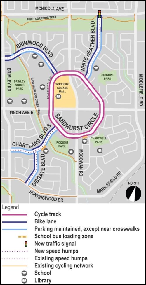
Revised Designs: Sandhurst Circle
Sandhurst Circle – typical:
- New bikeway: Cycle tracks separated from motor vehicles by low wall barriers, proposed to include painted artwork
- To maintain left turn lanes at McCowan Road and Finch Avenue East, there is no physical separation for the bikeway
- Speed limit reduction to 40 km/h in the northeast quadrant to match the rest of the street
- Parking is currently not allowed on Sandhurst Circle and will continue to be prohibited
- No changes to the number of motor vehicle lanes or driveway access.
Sandhurst Circle – in front of École élémentaire catholique Saint-Jean-de-Lalande
- In front of École élémentaire catholique Saint-Jean-De-Lalande, the on-street school bus loading zone will be maintained at the curb (same as existing conditions)
Revised Designs: Brimwood Boulevard
Brimwood Boulevard – typical
- Brimwood Boulevard has existing “urban shoulders” (edge lines) over which people are allowed to park
- The urban shoulder on one side of the street would be upgraded to a bike lane with painted buffer, and no parking in the bike lane
- The other urban shoulder (on the school side) would continue to allow parking and school drop-off and pick-up activity, except near pedestrian crossings to improve sightlines and safety.
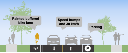
Revised Designs: Chartland Boulevard South and Dibgate Boulevard
Chartland Boulevard South and Dibgate Boulevard – typical
- New bikeway: Bike lane designated with wide painted buffer on one side of the street
- Speed humps and speed limit reduction to 30 km/h
- Parking maintained on one side of the street, including school drop-off and pick-up areas, except near pedestrian crossings to improve sightlines and safety
- No changes to the number of motor vehicle lanes or driveway access
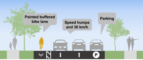
Revised Designs: White Heather Boulevard
White Heather Boulevard – typical
- New bikeway: Bike lane designated with wide painted buffer on one side of the street
- Parking maintained on one side of the street, including school drop-off and pick-up areas, except near pedestrian crossings to improve sightlines and safety
- White Heather Boulevard has existing speed humps and 30 km/h speed limit
- New traffic signal at White Heather Boulevard and McNicoll Avenue, where left-turns would not be permitted for motor vehicles to avoid increasing traffic on White Heather Boulevard and improve safety for school children, pedestrians and people cycling
Public Consultation
This project involves two phases of engagement.
In Phase One (from October to December 2025), the City engaged key interest groups, including the schools in the project area and Woodside Square Mall. Input from Phase One informed proposed changes to street design.
In Phase Two (ongoing), the City is consulting the public on the proposed changes to street design. Community members are invited to learn about the proposed changes, ask questions and provide feedback.
Public opinion, along with technical and policy considerations, will be used to inform staff recommendations and decisions made by City Council.
Public Drop-In Event
A Public Drop-In Event was held on February 28, 2026 that included the opportunity to speak with project staff and view information panels boards. View the information panels below.
Consultation Materials
Background
Vision Zero Road Safety Plan: This project is part of the Vision Zero Road Safety Plan, which aims to eliminate traffic-related fatalities and serious injuries by making our roads safer for everyone, especially for seniors, school children, pedestrians and people cycling.
Cycling Network Plan: The City Council approved 2025-2027 Near Term Implementation Program includes new cycling connections in the area of Sandhurst Circle that aim to connect gaps in the network and people to places and grow the cycling network in parts of the city.
Stay Informed
To receive project updates by email, please contact us and indicate that you would like to be added to the mailing list.