
Six Points Interchange construction completion celebration and official street naming ceremony – November 26, 2021.
The reconfiguration of the Six Points Interchange is complete. The City of Toronto would like to thank area residents and businesses for their continuous input and support throughout the project.
Following more than 10 years of planning, consultation, engineering and design, major construction to reconfigure the Six Points interchange began in March 2017 and substantial completion was reached in October 2020. The project included:
Watch a video about the evolution of the Six Points Interchange, including drone footage of the area taken in August 2021.
Watch a video of the removal of the Dundas Street West and Bloor Street West bridges over Kipling Avenue. The video is a time lapse and drone recording from the weekend of March 8-11, 2019.
Additional images may be available upon request. Please email media@toronto.ca.
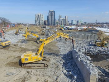
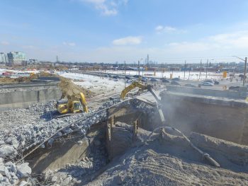
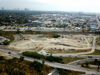
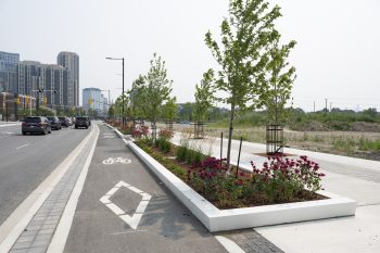
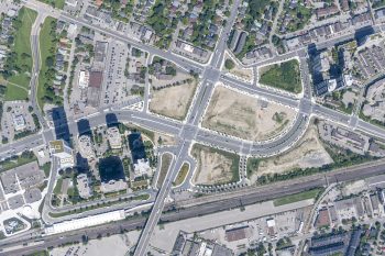
The new road network is designed to provide movement and access for all road users including vehicles, pedestrians and cyclists. The change from interchanges to the new road configuration includes lower speed limits and additional signalized intersections.
The new road network design takes into account all turning movements of trucks passing through the area and addresses safety issues at all intersections. Lane capacity and widths of the major arterial roads have been designed to accommodate all types of trucks.
Traffic signal timing coordination has been established to facilitate the movement of all traffic in the area, including pedestrian and cyclist usage. City Staff continue to review traffic conditions and signal timing on a regular basis and at various times throughout the day, including weekday rush hours, to assess how traffic is moving and adjusting to the new road conditions, and will determine if there are any issues and how to address them.
The new cycling infrastructure is part of the city-wide Cycling Network Plan.
Physically separated bike lanes have been constructed along:
In addition, the following were also created:
The new road network is designed as a complete street to provide safe and accessible movement for pedestrians, including widened sidewalks, street furniture, lighting, trees, planters and level intersection crossings.
Wherever possible, streetscape design elements (such as boulevard treatments, street furniture and trees) were extended along roads when they are rebuilt or adjacent land is redeveloped. Each area was designed to respond to the local context (such as condos and strip malls) and provisions were made for the safety of pedestrians and cyclists.
As a transit-oriented community, connections to the Kipling Transit Hub were an important part of this project. The reconfiguration of the roads around the Hub will ease congestion at this busy station, including the renovated kiss and ride.
The Kipling Transit Hub provides seamless mobility options to people and key destinations, including connections between the TTC, GO Transit and MiWay as well as improved car, bicycle and pedestrian access.
The following parks facilities were created or are planned (total of 10,340 m² of parkland):
The City will be consulting with the public about the design and development of future parks within the Six Points area. The public consultation process (anticipated to start in 2022) will consider park programming opportunities to support the current and future population, which includes facilities such as dog off-leash areas.
The City will maintain the trees and the BIA will maintain the planting beds along the new roadways.
Construction of the new Etobicoke Civic Centre is expected to begin in February 2023 and will be located at the intersection of Dundas Street West and Kipling Avenue. It will include:
Learn more on CreateTO’s website.
As part of the first phase of the Housing Now Initiative, two sites have been identified in Etobicoke Centre for new mixed-income housing, including new affordable rental units.
District Energy is a thermal energy distribution system for multiple buildings at the neighbourhood scale and consists of a heating and cooling centre and a thermal network of pipes connecting groups of buildings. District Energy systems have been in use in Toronto for more than 100 years and present no known risks to the public.
The realignment of Bloor Street West and Dundas Street West around Kipling Avenue created four new development blocks on the former Westwood Theatre Lands, which will be powered sustainably by a district energy system. There is potential for the expansion of District Energy to existing developments, however a business case will need to be evaluated for each.
While heating sidewalks with District Energy has been successful in some European cities, the Canadian winter is often more severe. To maximize efficiency and energy conservation, the pipes in Etobicoke Centre are highly insulated and will not be installed beneath the sidewalks. Instead, they will be short in length and used to heat and cool buildings.
Following extensive public engagement, three new street names were approved by Etobicoke York Community Council December 3, 2019.
City Council voted to rename Dundas Street at its July 14-15, 2021 meeting. Learn more about the Recognition Review.
An extensive public consultation program was carried out as part of the Six Points Interchange Reconfiguration Environmental Assessment from 2003–2007, and two community events helped shape the final design for the Reconfiguration in 2013 and 2014. Read the Environmental Assessment Report (2008) or the Executive Summary (see sections 1.10, 4.4, 5.6 for consultation details).
The project received a Certificate of Merit from the National Urban Design Awards in the Urban Design Plans category in 2018.